












1,291 named trails · 3,568.0 miles in Maricopa County · 1,496.6 miles open to Class 1 and 2 · 76 passages quoted from the bodies that wrote them · Rules verified October 29–30, 2026
Verified: every rule on this map is quoted from a public body's own text: the State of Arizona; Maricopa County; Phoenix, Scottsdale, Mesa, Chandler, Gilbert, Tempe, Glendale, Goodyear, Buckeye, Queen Creek and Fountain Hills; the Central Arizona Project; Arizona State Parks; and Congress, the Bureau of Reclamation, the Forest Service and the BLM. The rules were read October 29 and 30, 2026, by Milad Ghobadibeygvand, BScN; the method closes the page.
Quick Answer: On a Class 1 or 2 e-bike you may ride Arizona's bicycle and multiuse paths unless their manager says no; a Class 3 needs a roadside path or the manager's permission. Phoenix's desert parks, Scottsdale's McDowell Sonoran Preserve and most Tonto trails are closed. County parks take Class 1 and 2. SRP canal banks are federal land, and contested.
Our e-bikes ship free to you within the contiguous United States, Phoenix included. Browse our e-bikes, or let our Phoenix e-bike guide screen the shelf for you against Arizona's line of less than 750 watts and ten years of the Valley's hourly weather.

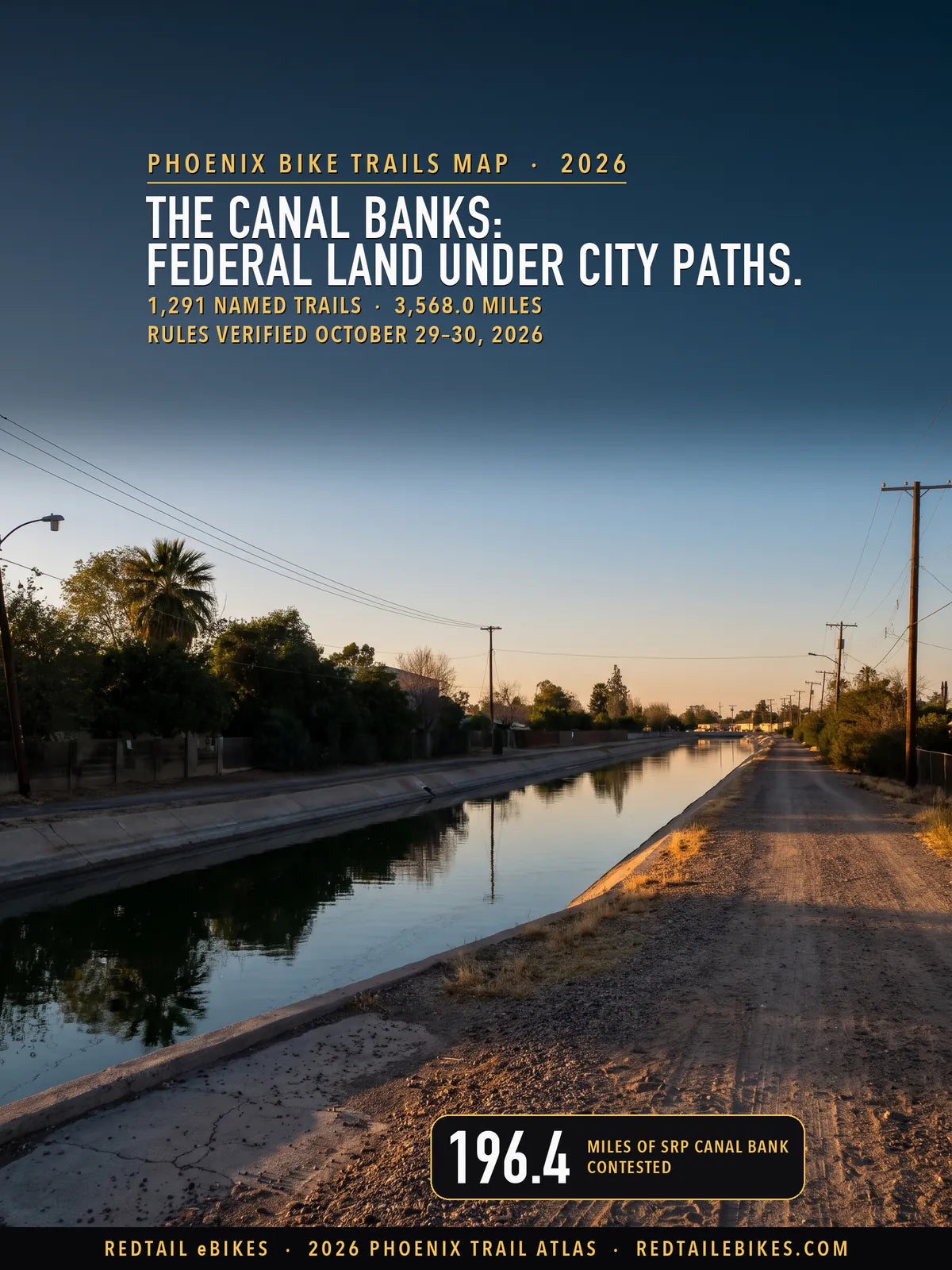
The Grand Canal in central Phoenix, whose banks this map reads contested for Class 1 and 2 e-bikes, in a scene generated with Playcut from a photograph of the canal by Mark S. Süever.

Blue and green fill the cities' path grids; the dashed red is Phoenix's preserves, the McDowell Sonoran Preserve and the Tonto National Forest to the east, and the amber lines are the Salt River Project's canals.
Arizona answers half the question in one subsection. A Class 1 or Class 2 e-bike "may be used on bicycle and multiuse paths", and then the catch: "A local authority or agency of this state having jurisdiction over a bicycle or multiuse path may prohibit the operation" of one on that path (§ 28-819(D)). So the state opens the door, and the local authority or state agency over a path may close it.
Class 3 starts from the other side. It "may not be operated on a bicycle or multiuse path unless it is within or adjacent to a highway or roadway or unless the local authority or agency of this state having jurisdiction over the path allows the operation" (§ 28-819(E)). That is why this map reads every trail twice, once for Class 1 and 2 and once for Class 3.
The managers have used that power. Phoenix keeps electric bicycles off the trails of every desert park and mountain preserve it runs, Scottsdale says "Electric bikes are not allowed in the Scottsdale McDowell Sonoran Preserve" (preserve page), and Chandler bars them from its canal paths. The federal agencies that hold the forest, the open desert and the land under the canals start from their own rules.
This map shows which of Maricopa County's 3,568.0 mapped miles of trail and off-street path your e-bike may ride, by class, on the rules read October 29 and 30, 2026, and who says so. It ties 24,934 pieces of trail from the managers' own files, such as Phoenix's and the County's, counted once, to the bodies whose rules govern each one; the trail register holds all of it as a download.
Takeaway
On a Class 1 or Class 2 you may ride 1,496.6 of this map's 3,568.0 miles, where every rule lets you, and 988.3 miles are closed by a published rule. On a Class 3 you may ride 475.4 miles. The other 1,083.1 miles for Class 1 and 2 are amber or gray: two rules disagree, or no rule that settles it could be read, so read the trailhead sign.
For the rest of Arizona's e-bike law, read Arizona e-bike laws, and every state's line sits in electric bike laws by state. For a shop to test-ride at, see the Phoenix e-bike shop directory or every verified shop in Arizona; for Tucson, read our Tucson e-bike guide.
E-bike trails by state compares the states, e-bike trails near me finds the atlas for yours, and the same method maps Houston's trails, Chicago's, Los Angeles's and New York City's bike paths.
In this guide
- How to read the map
- Who decides on each trail in Maricopa County
- The canal banks: federal land under city paths
- Phoenix's desert parks and mountain preserves are closed
- Maricopa County's regional parks
- Scottsdale and Fountain Hills
- The cities' own path rules
- Tonto National Forest, BLM land, wilderness and State Trust Land
- What the Legislature and the County are weighing
- Phoenix bike trails riders ask about
- Maricopa County trails, district by district
- Where riders get caught out
- Streets, bike lanes and sidewalks
- Choosing an e-bike for Phoenix's trails
- Frequently asked questions
How to read the map
Find your trail's color, then check your class. Green takes Class 1, 2 and 3. Blue takes Class 1 and 2, with Class 3 barred or its rule unread. Amber means two rules point different ways for Class 1 and 2, dashed red is closed by a published rule, and gray means no rule that settles it could be read, or no public manager is on record for the path.
| Color on the map | What it means | Miles | Share |
|---|---|---|---|
| Green | Open to Class 1, 2 and 3: every rule this map read lets all three classes ride it | 475.4 | 13% |
| Blue | Open to Class 1 and 2: Class 1 and 2 may ride it; Class 3 is barred there, or the rule that would decide Class 3 could not be read | 1,021.2 | 29% |
| Amber | Contested for Class 1 and 2: two rules point different ways for Class 1 and 2, most often a federal closure under a city's or the state's permission | 286.3 | 8% |
| Dashed red | Closed to e-bikes: a published rule closes it to every class | 988.3 | 28% |
| Gray | Not established: no rule that settles it could be read for the path's manager, or no public record names a manager | 796.9 | 22% |
Arizona's three classes come from the state's own definitions. A Class 1 assists "only when the rider is pedaling" and stops assisting at twenty miles per hour (§ 28-101(29)(a)); a Class 2 has a motor that "may be used exclusively to propel the bicycle or tricycle" up to the same speed ((b)); a Class 3 assists only while you pedal, up to twenty-eight miles per hour ((c)).
Whether a path is green or blue turns on Class 3. If you ride a Class 3, you need a path "within or adjacent to a highway or roadway" or a manager's permission (§ 28-819(E)), so the same path is blue on a quiet wash and green where it runs beside a street. The map counts a run as beside a road when half of it lies within 25 meters of one.
Each line comes from the managers' own trail files, the Maricopa Association of Governments' bikeways and OpenStreetMap, counted once where two draw the same ground. Streets, on-street bike lanes and proposed paths are left off; the street rules are under Streets, bike lanes and sidewalks. The map stops at the Maricopa County line.
Who decides on each trail in Maricopa County
The body that runs the ground decides, and on 62% of the mapped miles, preserves included, that is a city or town. Phoenix, Scottsdale, Gilbert and Goodyear hold the longest path grids; the County runs its regional parks; and federal agencies hold the forest to the east, the open desert to the west and, through Reclamation, the land under the canals.
| Who runs the path | Mapped miles | Class 1 and 2 | Class 3 |
|---|---|---|---|
| City of Phoenix desert parks and mountain preserves | 284.3 | Closed 284.3 | Closed 284.3 |
| Maricopa County regional parks | 250.2 | Open 250.2 | Open 1.9 · closed 248.4 |
| Scottsdale's McDowell Sonoran Preserve | 231.7 | Closed 231.7 | Closed 231.7 |
| Fountain Hills McDowell Mountain Preserve | 11.3 | Closed 11.3 | Closed 11.3 |
| Salt River Project canal banks (Reclamation land) | 213.0 | Contested 196.4 · closed 16.6 | Contested 34.5 · closed 178.5 |
| Other canal banks (Roosevelt Water Conservation District, County, City of Mesa, BLM, private) | 22.2 | Not established 22.2 | Not established 22.2 |
| Central Arizona Project's CAP Trail | 16.7 | Contested 16.7 | Contested 16.7 |
| Other Bureau of Reclamation land | 16.5 | Contested 16.5 | Contested 1.7 · closed 14.8 |
| Tonto National Forest | 245.5 | Open 1.6 · closed 243.8 | Open 1.6 · closed 243.8 |
| Designated wilderness | 107.3 | Closed 107.3 | Closed 107.3 |
| Bureau of Land Management | 172.8 | Open 28.4 · closed 88.9 · not established 55.5 | Open 28.4 · closed 88.9 · not established 55.5 |
| State Trust Land | 103.9 | Contested 28.4 · not established 75.5 | Contested 28.4 · not established 75.5 |
| Tribal land (Salt River Pima-Maricopa, Gila River) | 21.3 | Not established 21.3 | Not established 21.3 |
| City and town parks | 298.7 | Open 101.2 · contested 23.5 · closed 4.2 · not established 169.7 | Open 25.7 · contested 23.5 · closed 79.7 · not established 169.7 |
| City and town paths outside parks | 1,375.6 | Open 1,033.9 · contested 4.6 · not established 337.1 | Open 402.9 · contested 4.6 · closed 385.3 · not established 582.8 |
| Private and HOA paths | 113.1 | Not established 113.1 | Not established 113.1 |
| Unincorporated county land, no manager on record | 83.7 | Open 81.2 · not established 2.5 | Open 14.9 · closed 66.3 · not established 2.5 |
Read the table by your class. On a Class 1 or Class 2 you are welcome on most city paths and, by the County's policy, in its regional parks, and kept out of the preserves and most of the forest. On a Class 3 you lose most of the County parks (County FAQ), Mesa's and Chandler's shared-use paths (Mesa § 6-10-7(D), Chandler § 13-9-3) and most canal banks away from a road.
Amber: two rules, one path
On 286.3 miles two rules disagree for Class 1 and 2. Most of them are Salt River Project canal banks, where a federal regulation closes the land to e-bikes and the city's path rule, or the state's, lets you ride. The next section reads both.
The rest are 28.4 miles of the Maricopa Trail across State Trust Land, 23.5 of Glendale's park paths, 16.7 of the CAP Trail, 16.5 of other Reclamation land and 4.6 of Scottsdale's unpaved trails.
The CAP Trail's own page says it "is for multiple non-motorized recreational uses" and that "public motorized uses will not be allowed" (CAP), while Arizona says an electric bicycle is not a motor vehicle (§ 28-101(53)). Glendale's park rules say "Motorized vehicles are restricted to paved roads" (park rules), with the same tension.
On Trust Land the County's policy opens the Maricopa Trail to Class 1 and 2, while the State Land Department asks a permit for "traveling on existing trails over Trust Land" (Arizona State Parks) whose terms could not be read.
Takeaway
Amber does not mean you may ride. On the canals the federal rule says it "will govern over any conflicting regulations of a non-Federal entity" (43 CFR 423.3(f)), so a city's permission is the weaker of the two.
68% of the Valley's open miles are blue: open to Class 1 and 2, closed or unread for Class 3. Our Phoenix guide screens the shelf against Arizona's definition and picks bikes for canal commutes and summer heat.
Find a Phoenix e-bike under Arizona's 750-watt lineThe canal banks: federal land under city paths
The Salt River Project's canal banks are Bureau of Reclamation land, and Reclamation's rule closes Reclamation land to e-bikes unless its Regional Director opens it. No decision opening these canals was found. The cities' path rules, or the state's where no city rule was read, let Class 1 and 2 ride them, so 196.4 of the map's 213.0 miles of SRP canal bank read amber for Class 1 and 2.

Amber covers the Arizona, Grand, Western, Consolidated, Tempe and Eastern canals; Chandler's stretches are red, and the gray line in the east is the Roosevelt Water Conservation District canal path, whose e-bike rule could not be read.
Reclamation's own page says what the land is. "In September 2022, all Bureau of Reclamation lands underlying and adjacent to canals, open ditches, and licensed municipal paths over underground facilities of the Salt River Federal Reclamation Project became a Special Use Area in accordance with 43 C.F.R. Part 423, Subpart E" (Reclamation, Phoenix Area Office).
The area's own rules, as Reclamation's page lists them, add two prohibitions and name no e-bike allowance: "The Special Use Area has the following additional prohibitions, which vary from the standard Rules of Conduct specified in 43 C.F.R. Part 423, Subpart C: No Fires. No Camping." (Reclamation).
Its map of that area draws the Valley's main canals, their open ditches and the licensed paths, and the same page names "Salt River Project / Salt River Water Users Association" the project's "operating and maintaining entity" (Reclamation).
SRP's predecessor took control of the project's canals under a contract of 1917: "The contract was drawn up on September 6, 1917, and the Association took control on November 1, 1917" (Reclamation's project history).
Where a non-federal body runs Reclamation land "through a contract or other written agreement", public conduct "will be regulated by this part 423 as well as any regulations established by the entity, the terms of the entity's contract with Reclamation, and applicable Federal, State, and local law" (§ 423.3(c)), so the federal rule and the local ones apply together.
Scottsdale's own police told the City's Transportation Commission on May 21, 2026, that "canal paths fall under Federal jurisdiction" (commission minutes).
The federal rule on a canal bank, in three steps: Part 423 brings in the off-road-vehicle rule (§ 423.40(d)), that rule closes Reclamation land to off-road vehicles unless an area is opened (§ 420.2), and your e-bike is one unless the Regional Director decides otherwise (§ 420.5(a)(7)).
On that land, Part 423 adds: "In addition to the regulations in this part, the regulations governing off-road-vehicle use in 43 CFR part 420 apply" (§ 423.40(d)). Part 420 opens with a closure: "Reclamation lands are closed to off- road vehicle use, except for an area or trail specifically opened to use of off- road vehicles in accordance with § 420.21" (§ 420.2; the space is the regulation's own).
Your e-bike counts as an off-road vehicle there, and the rule excludes it only "where the Regional Director has expressly determined, as part of a land-use planning or implementation-level decision, that E-bikes should be treated the same as non-motorized bicycles" (§ 420.5(a)(7)).
Reclamation's Lower Colorado Basin made that kind of decision in June 2025 for trails on its lands "along the Colorado River and its tributaries of the Las Vegas Wash, Virgin River, and Muddy River that flow into Lake Mead" (EA LC-24-22).
The same document says "The use of all E-bikes would remain prohibited on other Reclamation lands within the Project Area that have not been specifically opened to E-bike use" (EA LC-24-22). It does not reach Maricopa County.
The stakes are federal. Part 423's own sanction, for breaking its rules on Reclamation land, reads: "you are subject to a fine under chapter 227, subchapter C of title 18 United States Code (18 U.S.C. 3571), or can be imprisoned for not more than 6 months, or both" (§ 423.71).
What each city's path rule says
Chandler closes its canal paths to e-bikes. Mesa, Gilbert, Tempe and Glendale let them ride multi-use paths, and the rules quoted here do not set the canals apart; Scottsdale's and Phoenix's paths read by the state's rule. Chandler's release puts it plainly: "No motorized vehicles, including E-bikes, are permitted on canal shared-use paths, such as the Paseo Trail and Western Canal Path" (Chandler).
| City | SRP canal-bank miles | Class 1 and 2 | Class 3 | What the city's own rule says |
|---|---|---|---|---|
| Phoenix | 80.1 | Contested 80.1 | Contested 5.9 · closed 74.1 | The City's e-bike article could not be read; the state's path rule is applied |
| Mesa | 41.6 | Contested 41.6 | Closed 41.6 | Class 1 and 2 on City shared-use paths |
| Gilbert | 23.5 | Contested 23.5 | Contested 23.5 | E-bikes on multi-use paths except where posted |
| Tempe | 17.7 | Contested 17.7 | Contested 0.4 · closed 17.3 | E-bikes on multi-use paths at 15 mph |
| Scottsdale | 15.7 | Contested 15.7 | Contested 3.0 · closed 12.7 | Its e-bike summary sets no path rule; the state's path rule applies |
| Glendale | 9.3 | Contested 9.3 | Contested 1.4 · closed 7.8 | E-bikes may ride where bicycles may, unless signed |
| Chandler | 16.6 | Closed 16.6 | Closed 16.6 | No e-bikes on canal paths |
| Unincorporated county | 8.5 | Contested 8.5 | Contested 0.2 · closed 8.3 | The County's ordinance is still being drafted; the state's path rule applies |
Mesa's ordinance lists the "CLASS 1 ELECTRIC BICYCLE, CLASS 2 ELECTRIC BICYCLE" among what a person may ride on a shared-use path (Ordinance No. 5994, § 6-10-7(B)), and Gilbert lets e-bikes use "sidewalks, multi‑use paths, and in Town parks, except where posted signage prohibits their use" (Gilbert). Neither text names the federal rule, and neither can set it aside.
On a Class 3 you have less room still. Away from a road, Arizona keeps your Class 3 off paths unless the manager allows it, so on 178.5 canal-bank miles the state's limb and the federal rule both close the path to Class 3. Mesa adds its own: "ALL OTHER MOTOR VEHICLES AND MOTORIZED ELECTRIC VEHICLES ARE PROHIBITED ON A SHARED-USE PATH" (§ 6-10-7(D)).
Riding the Arizona Canal or the Grand Canalscape? On a Class 1 or Class 2 you ride with the city's or the state's permission and without Reclamation's. Watch for signs at the canal crossings, keep to the city-built paved paths, and never ride an e-bike on a Chandler canal path.
The CAP Trail
The Central Arizona Project's trail runs 16.7 mapped miles across north Phoenix and Scottsdale. Its own page says the trail "is for multiple non-motorized recreational uses: walking, jogging, equestrian, cycling and roller blading" and that "public motorized uses will not be allowed" (CAP). Arizona's definitions leave an e-bike outside "motor vehicle" (§ 28-101(53)), so the map reads it amber; if you meet a CAP sign that names e-bikes, it settles the question.
Phoenix's desert parks and mountain preserves are closed
Whatever class you ride, you may not ride a trail in any of Phoenix's desert parks or mountain preserves. The City's Code of Conduct lists what "is not permitted in any desert park or mountain preserve", and one line reads "Riding electric bicycles or other types of motorized vehicles on trails or off established park roads" (Code of Conduct).
Both halves of that line matter. The first closes the trails, and the second closes everything that is not an established park road, the paved paths in Papago Park, Reach 11 and the Rio Salado Habitat Restoration Area included, all three on the City's own list of its desert parks and preserves (Phoenix trails). That puts 284.3 mapped miles off limits to every class.
| Desert park or preserve | Mapped miles |
|---|---|
| South Mountain | 110.9 |
| Phoenix Sonoran Preserve | 56.7 |
| Piestewa Peak and the Phoenix Mountains Preserve | 49.8 |
| Rio Salado Habitat Restoration Area | 15.3 |
| Papago Park | 13.9 |
| Reach 11 Recreation Area | 13.6 |
| Deem Hills | 13.4 |
| North Mountain and Shaw Butte | 3.9 |
| Lookout and Shadow Mountain | 3.1 |
| Camelback Mountain | 2.9 |
| Ludden Mountain | 0.8 |
| All of them, closed to every class | 284.3 |
The City counts "more than 41,000 acres of desert parks and mountain preserves, and 200-plus miles of trails" (Phoenix trails). The map's 284.3 miles count every mapped line in them, spurs, connectors and paved paths included.

South Mountain's 110.9 mapped miles, National Trail and Desert Classic included, are closed to every class of e-bike.
South Mountain
Every trail in South Mountain Park/Preserve is closed to e-bikes. The National Trail, Desert Classic, Mormon, Holbert and Kiwanis trails are all inside it. Ride a pedal bike where the trail allows one, or ride your e-bike on the established park roads the Code's line leaves outside its ban.
The one way in: park roads
The Code's last words, "off established park roads," leave the established roads through the preserves outside its ban (Code of Conduct). Ride them as road traffic: you share them with cars and their speed limit.
Maricopa County's regional parks
The County's policy opens the bicycle and multi-use trails of its regional parks to Class 1 and 2 and keeps Class 3 to paths beside a road. It reads: "Class 1 and Class 2 e-bikes are allowed on bicycle and multi-use trails, unless otherwise restricted by park management" (County FAQ).
For Class 3 the County repeats the state's limb: "Class 3 e-bikes are not allowed on multi-use or bike paths unless the path is adjacent to a roadway or specifically permitted by park management" (County FAQ). On a Class 3 you can ride only 1.9 of the County's 250.2 mapped miles, the ones beside a road.
| County regional park | Mapped miles | Class 1 and 2 | Class 3 |
|---|---|---|---|
| McDowell Mountain Regional Park | 83.9 | Open 83.9 | Closed 83.9 |
| Estrella Mountain Regional Park | 61.5 | Open 61.5 | Open 1.0 · closed 60.5 |
| White Tank Mountain Regional Park | 41.0 | Open 41.0 | Closed 41.0 |
| Usery Mountain Regional Park | 24.9 | Open 24.9 | Open 0.2 · closed 24.7 |
| Cave Creek Regional Park | 16.2 | Open 16.2 | Closed 16.2 |
| Lake Pleasant Regional Park | 13.2 | Open 13.2 | Open 0.5 · closed 12.7 |
| Spur Cross Ranch Conservation Area | 5.4 | Open 5.4 | Open 0.2 · closed 5.2 |
| Desert West Regional Park | 1.7 | Open 1.7 | Closed 1.7 |
| Saguaro Ranch Park | 1.5 | Open 1.5 | Closed 1.5 |
| Vulture Mountains Recreation Area North Lease Area | 0.6 | Open 0.6 | Closed 0.6 |
| Foothills Park | 0.2 | Open 0.2 | Closed 0.2 |
| All 11 | 250.2 | Open 250.2 | Open 1.9 · closed 248.4 |
The policy carries its own date: "E-Bike Policy (Effective January 1, 2019)" (County FAQ). McDowell Mountain, Estrella Mountain and White Tank Mountain hold the County's competitive tracks, all of them open to you on a Class 1 or 2.
Usery's Pass Mountain Trail leaves the park
Most of the Pass Mountain Trail is Tonto National Forest, and closed to e-bikes. Of its 9.0 mapped miles, 7.2 lie on the Tonto, where the Forest Service's trail file carries it as trail 282 (Forest Service trails), and 1.7 inside Usery Mountain Regional Park, where the County's policy opens it to Class 1 and 2.
On the Tonto an e-bike counts as a motor vehicle (36 CFR 212.1), which rides only the forest's designated routes (36 CFR 261.13); this trail is not one, so turn your e-bike back where it leaves the park.
The County parks are open to a Class 1 e-MTB. Our mountain-bike guide picks full-suspension and mid-drive e-MTBs for rocky ground and long climbs, and explains the class that decides where you may ride them.
Pick an e-MTB for the County's desert singletrackScottsdale and Fountain Hills
The McDowell Sonoran Preserve
You may not ride any e-bike in the McDowell Sonoran Preserve, 231.7 mapped miles of it. Scottsdale's page says "Electric bikes are not allowed in the Scottsdale McDowell Sonoran Preserve" (preserve), and its preserve rules list "Electric Scooters, motorized bicycles, electric bicycles or any other non-self-propelled vehicle or device (excluding motorized wheelchairs)" as "prohibited on Preserve trails" (preserve rules).
Fountain Hills closes its part of the McDowell Mountains the same way. Its town code bars "Using any motorized or electric mode of transportation, except for authorized maintenance vehicles and as necessary" in the preserve (§ 9-5-3(P)), 11.3 mapped miles.
Scottsdale's paths and the Indian Bend Wash
Outside the preserve, Scottsdale's own summary of its e-bike laws sets no path rule beyond the state's, so on a Class 1 or 2 you may ride its paths, the Indian Bend Wash Greenbelt among them, by § 28-819(D). Its unpaved trails read amber: "The city prohibits the use of motorized vehicles, including ATVs and motorcycles, on Scottsdale's trails" (Scottsdale), and an e-bike is not a motor vehicle under state law.
On June 15, 2026, the City said it "plans to establish designated pedestrian safety zones in high-traffic areas of Chaparral Park, Mountain View Park and Scottsdale Ranch Park where the operation of e-bikes and other motorized devices will be prohibited", marked with signs (Scottsdale). The zones are not on this map, so if you ride through those three parks, follow the signs.
If you are buying for a rider under sixteen, Scottsdale draws its line at age. Section 17-77.1 bars anyone under sixteen from riding "class three electric bicycles, similar devices that can meet or exceed twenty-one (21) miles per hour (MPH) on city property" (Scottsdale), and "A violation of this section is a civil traffic offense and shall be punished by a minimum of one hundred (100) dollars" (Scottsdale).
The cities' own path rules
The Valley's cities have written their own e-bike rules, and they do not agree, so the city you ride in matters. Gilbert opens its paths and parks to e-bikes without excepting a class, Chandler and Mesa keep Class 3 off theirs, and Queen Creek keeps e-bikes out of its parks.
| City or town | Its own rule for paths | Path miles | Class 1 and 2 | Class 3 |
|---|---|---|---|---|
| Phoenix | Class 1 and 2 legal on public streets since 2022; the City's e-bike article could not be read | 252.7 | Open 245.7 · not established 7.0 | Not established 252.7 |
| Mesa | Class 1 and 2 on City shared-use paths; every other motorized device prohibited | 70.8 | Open 60.9 · not established 10.0 | Closed 60.9 · not established 10.0 |
| Chandler | Class 1 and 2 at 15 mph off the canals; Class 3 off paths, sidewalks and parks | 75.4 | Open 74.8 · not established 0.6 | Closed 74.8 · not established 0.6 |
| Gilbert | E-bikes on sidewalks, multi-use paths and in Town parks, except where posted | 138.6 | Open 137.3 · not established 1.3 | Open 137.3 · not established 1.3 |
| Scottsdale | Its e-bike summary sets no path rule beyond the state's; under-16s off Class 3 on city property | 255.1 | Open 249.3 · contested 4.6 · not established 1.2 | Open 146.8 · contested 4.6 · closed 102.4 · not established 1.2 |
| Tempe | E-bikes on multi-use paths at 15 mph since July 25, 2026 | 31.0 | Open 29.9 · not established 1.1 | Open 4.8 · closed 25.1 · not established 1.1 |
| Glendale | E-bikes where bicycles may ride, unless signed | 35.1 | Open 35.0 · not established 0.1 | Open 4.9 · closed 30.1 · not established 0.1 |
| Goodyear | Class 3 on shared-use paths at 20 mph or less | 120.0 | Open 82.8 · not established 37.2 | Open 82.8 · not established 37.2 |
| Queen Creek | 15 mph on multi-use trails; e-bikes out of Town parks | 58.1 | Open 57.6 · not established 0.6 | Open 10.3 · closed 47.2 · not established 0.6 |
| Buckeye | New e-bike section in force November 6, 2026 | 68.5 | Open 60.7 · not established 7.8 | Open 15.9 · closed 44.8 · not established 7.8 |
| Peoria | Could not be read: the City's site answered with a challenge page | 119.5 | Not established 119.5 | Not established 119.5 |
| Surprise | No Surprise e-bike rule for paths was read | 80.1 | Not established 80.1 | Not established 80.1 |
| Avondale | Could not be read: the City's site refused this research client | 45.0 | Not established 45.0 | Not established 45.0 |
In Chandler you are held to 15 mph: its ordinance, in force since July 11, 2026 (Chandler), says "CLASS 1 AND CLASS 2 ELECTRIC BICYCLES SHALL NOT EXCEED A SPEED OF 15 MILES PER HOUR WHILE OPERATING ON A SIDEWALK OR SHARED USE PATH OR WITHIN A CITY PARK" (Ordinance No. 5164).
Its Class 3 section reads: "THE OPERATION OF CLASS 3 ELECTRIC BICYCLES IS PROHIBITED ON SIDEWALKS, IN CITY PARKS, AND ON SHARED-USE PATHS WITHIN THE CITY OF CHANDLER" (§ 13-9-3).
Mesa opened its parks on February 11, 2026: "Effective Feb. 11, 2026, Class 1 and Class 2 E-Bikes, electric standup scooters, and electric miniature scooters may be ridden within a Mesa park" (Mesa).
In a Mesa park you are held to five miles per hour: "NO PERSON SHALL DRIVE, RIDE, OR OPERATE A CLASS 1 ELECTRIC BICYCLE, CLASS 2 ELECTRIC BICYCLE, ELECTRIC STANDUP SCOOTER, OR ELECTRIC MINIATURE SCOOTER IN A PARK AT A SPEED GREATER THAN FIVE MILES PER HOUR" (Ordinance No. 5995).
In Tempe your path limit is 15 mph: "The speed limit for electric bicycles on multi-use paths was lowered from 20 mph to 15 mph" (Tempe). In Glendale a sign that bars bicycles bars you too: "Where authorized signs are erected on a roadway, Sidewalk, or other pathway prohibiting the riding of bicycles, no person shall operate an E-Bike or E-Scooter thereon" (Ordinance No. O25-50).
In Queen Creek you may not ride an e-bike in the Town's parks: "Electric bikes, other power-driven mobility devices and motor vehicles are not allowed in Town parks, including sidewalks within the park" (Queen Creek). Goodyear lists "Class 3 e‑bikes exceeding 20 MPH on shared‑use paths" among the actions it does not permit (Goodyear), which the map reads as letting you ride a Class 3 on those paths at 20 mph or less.
Phoenix's streets and paths
Phoenix has let you ride a Class 1 or 2 on its streets since 2022: the Council adopted "Electric Bicycle Legalization (Ordinance G-6967)" on March 2 (Council record), a change that "will permit the use of Class 1 and Class 2 e-bikes in the public right-of-way" (Council agenda).
Off the street, 245.7 of the City's 252.7 mapped miles of path outside its parks read open to Class 1 and 2 by the state's rule. The City's own e-bike article, "PCC 36-500-514" in its police guide (Phoenix police), could not be read, so Class 3 reads not established on these paths, and if you meet a posted sign, it outranks this map.
Buckeye, from November 6
Buckeye's new section is adopted and not yet in force: "Ordinance 12-2-10 goes into effect November 6, 2026" (Buckeye). From November 6, 2026, you may ride its parks on a Class 1 or 2 and not a Class 3, by the City's own table (Buckeye).
If you break the rule from November 6, 2026, the fines start at "Violation $100 Fine Second Violation Within 12 Months $250 Fine Third Violation Within 12 Months $500 Fine, Device Impound up to One Year Plus Fees" (Buckeye).
Commuting on the city grids? Our commuter guide's checklist sorts what a daily ride to work needs from what it does not, racks and fenders included.
Compare commuter e-bikes for the Valley's path gridTonto National Forest, BLM land, wilderness and State Trust Land
On federal land your e-bike starts as a motor vehicle, and you ride only where the agency says you may. The Forest Service defines a motor vehicle as "Any vehicle which is self-propelled, other than:" a short list of exceptions that does not include e-bikes (36 CFR 212.1).
The Tonto National Forest then allows motor vehicles only on its designated routes: "it is prohibited to possess or operate a motor vehicle on National Forest System lands in that administrative unit or Ranger District other than in accordance with those designations" (36 CFR 261.13). Of the forest's 245.5 mapped miles in the county, 1.6 miles are designated for e-bikes on its motor vehicle use map, and 243.8 miles are closed.
Our guide to e-bikes on national forests and other public land reads those federal rules, which each forest applies through its motor vehicle use map.
Wilderness closes even your pedal bike. The Wilderness Act allows "no other form of mechanical transport" (16 U.S.C. § 1133(c)), so the Four Peaks, Superstition and Mazatzal wildernesses' 107.3 mapped miles in the county are closed to every bicycle.
The BLM treats an e-bike as an off-road vehicle unless "the authorized officer has expressly determined, as part of a land-use planning or implementation-level decision, that e-bikes should be treated the same as non-motorized bicycles" (43 CFR 8340.0-5), and its own e-bike page says the rule "does not, by itself, open any non-motorized trails to e-bike use" (BLM).
Its route file decides the rest: 6.3 miles are coded "Shared Motorcycle, ATV, Mountain Bike, Electric Mountain Bike, Equestrian, Hiking" (BLM), and 22.2 more are motorcycle routes; the BLM's advice to e-bike riders is to "Search for an Open OHV area or motorized trail to ride your e-bike" (BLM).
The non-motorized codes, such as "Shared Non-Motorized (Hiking, Bicycle, Equestrian)" (BLM), cover 88.9 miles, all closed to your e-bike, and another 55.5 miles carry no use code the map could read.
| The BLM's route code | Mapped miles | Your e-bike, any class |
|---|---|---|
| Shared Motorcycle, ATV, Mountain Bike, Electric Mountain Bike, Equestrian, Hiking | 6.3 | Open |
| Motorcycle Shared | 22.2 | Open: a motorized trail |
| Shared Non-Motorized (Hiking, Bicycle, Equestrian); Bicycle and Hiking Only | 88.9 | Closed |
| No use code in the file | 55.5 | Not established |
| All BLM trail in the county | 172.8 |
On the Black Canyon National Recreation Trail the BLM's 2022 travel plan for the corridor puts it plainly: "For the TMP the field office considers e-bikes an OHV and will not be permitted on Limited to non-motorized use routes" (Black Canyon Corridor travel plan).
Of the trail's 25.4 mapped miles in the county, 13.9 read closed and 11.1 not established; 0.2 read open and 0.2 amber where it crosses a motorized route or State Trust Land.
On State Trust Land you need a permit. Arizona State Parks says "A recreation permit is required for: hiking, horseback riding, picnicking, photography, bird watching, sightseeing, camping or traveling on existing trails over Trust Land" (Arizona State Parks), and the permit's own terms could not be read, so 75.5 mapped miles read not established.
The Maricopa Trail across it was "purchased from the Trust as perpetual Rights of Way, making them available to the public" (Arizona State Parks); its 28.4 miles there read amber.
Hawes: a trail system split by a forest line
The Hawes trails sit half in the Tonto and half outside it, so one ride crosses two rules. The map holds 15.9 miles under the Hawes names: 4.7 miles on the Tonto are closed to e-bikes, 3.4 miles outside the forest read open to Class 1 and 2, and 7.8 miles of singletrack outside the forest have no public manager on record.
If you ride an e-MTB from the Mesa side, the forest boundary is where your ride ends, because the Tonto allows a motor vehicle only on its designated routes (36 CFR 261.13).
The Arizona Trail
The Arizona Trail's 28.2 mapped miles under its own name in the county lie on the Tonto, and where it shares a route with another trail it crosses the Mazatzal Wilderness, as on Saddle Mountain Trail #91; you may not ride your e-bike on any of it (36 CFR 261.13, 16 U.S.C. § 1133(c)).
What the Legislature and the County are weighing
Two 2026 bills would have capped e-bike speeds on Arizona's paths and sidewalks, and neither became law. SB 1008 said an e-bike "may not exceed fifteen miles per hour while in use on a bicycle or multiuse path if the path is clear of other persons", and SB 1073 that a rider "MAY NOT EXCEED A SPEED OF FIFTEEN MILES PER HOUR ON A SIDEWALK."
The Legislature's own records list SB 1008 as "Held awaiting Second Reading" and SB 1073 as "Held in Committees", with no chapter number and no governor's action. None of the 264 laws chaptered in 2026, whose general effective date was September 12, 2026, or the 265 of 2025 (session laws) names bicycles or paths in its title.
Maricopa County is writing its own rule for unincorporated land. The District 3 supervisor wrote on September 30, 2026: "I am pleased to announce an ordinance for unincorporated Maricopa County land is being drafted in accordance with existing state statute" (County bulletin).
The Board's next formal meeting is "Wednesday November 4, 2026 9:30 am Formal Supervisors' Auditorium" (Board calendar), and "The Draft agenda and supportive documentation are often available 3 days before the meeting for a Formal Meeting" (Board meetings). No draft text was posted as of October 29, 2026, so this map reads the paths you ride on unincorporated land by the state's rule.
Takeaway
As of October 29, 2026, the state's rule governed unincorporated paths and the County's draft was not law; Buckeye's section takes effect November 6, 2026. Check this map again after each, before you ride.
Phoenix bike trails riders ask about
These are the trails search and forum questions name, with what you may ride on each. A trail's miles count every mapped line under its name, both banks of a canal included, so the named miles overlap and do not add up to the county's total.
| Trail | Mapped miles | Class 1 and 2 | Class 3 | Who runs most of it |
|---|---|---|---|---|
| Arizona Canal Trail | 88.3 | Open 4.2 · contested 69.7 · closed 0.4 · not established 14.1 | Contested 9.4 · closed 62.4 · not established 16.6 | Salt River Project canal (Reclamation land); Salt River Reservation |
| Grand Canal Path | 62.3 | Open 3.4 · contested 58.9 | Open 0.3 · contested 3.6 · closed 58.2 · not established 0.2 | Salt River Project canal (Reclamation land); Glendale city |
| Grand Canalscape | 37.6 | Open 0.6 · contested 37.0 | Contested 2.7 · closed 34.9 | Salt River Project canal (Reclamation land); Glendale city |
| Western Canal Path | 27.8 | Open 0.1 · contested 24.5 · closed 0.5 · not established 2.7 | Contested 2.5 · closed 22.5 · not established 2.7 | Salt River Project canal (Reclamation land); Western Canal |
| Consolidated Canal Path | 9.0 | Open 0.6 · contested 7.3 · closed 1.1 | Open 0.4 · contested 4.2 · closed 4.4 | Salt River Project canal (Reclamation land); Freestone Park |
| Crosscut Canal Path | 9.9 | Open 0.2 · contested 4.1 · closed 5.0 · not established 0.5 | Contested 1.8 · closed 7.5 · not established 0.5 | Papago Park I; Salt River Project canal (Reclamation land) |
| Tempe Canal Trail | 11.2 | Contested 11.2 | Closed 11.2 | Salt River Project canal (Reclamation land) |
| Chandler Paseo Trail | 14.2 | Open 0.2 · contested 3.1 · closed 10.8 | Contested 0.2 · closed 13.9 | Salt River Project canal (Reclamation land); Chandler city |
| Rio Salado Pathway | 10.0 | Open 4.6 · contested 0.7 · not established 4.7 | Open 1.0 · contested 0.2 · closed 4.1 · not established 4.7 | Rio Salado Park; Tempe city |
| Tempe Town Lake North Path | 4.1 | Open 0.3 · not established 3.8 | Not established 4.0 | Rio Salado Park; Town Lake Marina |
| Indian Bend Wash Trail | 14.3 | Open 12.1 · not established 2.2 | Open 2.3 · closed 4.1 · not established 7.9 | Phoenix city; Scottsdale city |
| Dreamy Draw Bikeway | 6.1 | Open 1.3 · closed 4.9 | Closed 4.9 · not established 1.3 | Piestewa Peak; Phoenix Mountain Preserve |
| National Trail | 17.1 | Closed 17.1 | Closed 17.1 | South Mountain |
| Desert Classic Trail | 14.4 | Closed 14.4 | Closed 14.4 | South Mountain |
| Mormon Trail | 2.0 | Closed 2.0 | Closed 2.0 | South Mountain |
| Holbert Trail | 3.9 | Closed 3.9 | Closed 3.9 | South Mountain |
| Kiwanis Trail | 1.0 | Closed 1.0 | Closed 1.0 | South Mountain |
| Maricopa Trail | 328.2 | Open 102.0 · contested 77.6 · closed 95.8 · not established 52.7 | Open 50.9 · contested 57.4 · closed 164.4 · not established 55.5 | State Trust Land; Tonto National Forest |
| Sun Circle Trail | 213.4 | Open 40.3 · contested 83.3 · closed 36.6 · not established 53.2 | Open 13.0 · contested 12.1 · closed 121.0 · not established 67.3 | Salt River Project canal (Reclamation land); South Mountain |
| Arizona Trail | 28.2 | Closed 28.2 | Closed 28.2 | Tonto National Forest |
| New River Trail | 25.8 | Open 4.7 · contested 0.5 · not established 20.6 | Open 1.1 · closed 3.8 · not established 20.9 | Peoria city; Glendale city |
| Upper Hawes | 14.4 | Open 3.4 · closed 3.2 · not established 7.8 | Closed 6.6 · not established 7.8 | Mesa city; Tonto National Forest |
| Hawes Trail | 6.9 | Closed 6.9 | Closed 6.9 | Tonto National Forest |
| Usery Mountain Trails | 26.0 | Open 19.5 · closed 6.6 | Open 0.2 · closed 25.8 | Usery Mountain Regional Park; Tonto National Forest |
| Pass Mountain Trail | 9.0 | Open 1.7 · closed 7.2 | Closed 9.0 | Tonto National Forest; Usery Mountain Regional Park |
| McDowell Competitive Track | 13.6 | Open 13.6 | Closed 13.6 | McDowell Mountain Regional Park |
| Estrella Competitive Track - Long Loop | 12.2 | Open 12.2 | Closed 12.2 | Estrella Mountain Regional Park |
| Salt River Trail | 6.1 | Closed 6.1 | Closed 6.1 | Tonto National Forest |
| Reach 11 Trail | 2.6 | Closed 0.5 · not established 2.0 | Closed 0.5 · not established 2.0 | AZ Horse Lover’s Park; Reach 11 Rec Area |
The Arizona Canal Trail counts 88.3 mapped miles, both banks included, and 69.7 of them read amber for Class 1 and 2, because its banks are Reclamation land (Reclamation). The Maricopa Trail runs 328.2 mapped miles across city, County, federal, State Trust and tribal land; 102.0 of them read open to Class 1 and 2.
Riding the Indian Bend Wash or a County park loop? Those are the open miles. Our Phoenix guide matches a bike to them, and to July.
See the e-bikes our Phoenix guide picksMaricopa County trails, district by district
The county's five supervisorial districts carry very different maps, so find yours. District 2 holds the most miles, 1,237.7, and 569.7 of the closed ones; District 3 has the fewest miles open to Class 3, 0.7.
| Supervisorial district | Mapped miles | Open to Class 1 and 2 | Contested | Closed or not established |
|---|---|---|---|---|
| District 1 | 543.6 | 390.5 | 40.9 | 112.1 |
| District 2 | 1,237.7 | 478.9 | 86.4 | 672.4 |
| District 3 | 528.7 | 145.6 | 59.9 | 323.2 |
| District 4 | 638.6 | 202.8 | 57.9 | 377.8 |
| District 5 | 619.5 | 278.8 | 41.0 | 299.6 |

District 1
District 1 holds 543.6 mapped miles of trail and path: 390.5 open to Class 1 and 2, 40.9 contested, 70.0 closed and 42.1 not established; 167.4 of them are open to Class 3.
District 1's mapped miles lie mostly in Gilbert (182.6 mi), Chandler (127.0 mi), Phoenix (85.3 mi), Queen Creek (62.4 mi) and Tempe (47.3 mi). Its largest park or preserve on the map is South Mountain (48.9 mi). The district lines are the County's own (districts).
In District 1 you'll find Gilbert's green path grid, Chandler's blue paths and red canal paths, and the SRP canals amber between them.
| Trail | Mapped miles | Class 1 and 2 | Class 3 |
|---|---|---|---|
| Maricopa Trail (San Tan - Freestone) | 21.8 | Open 15.9 · contested 3.7 · closed 2.2 | Open 12.7 · contested 3.7 · closed 5.4 |
| Eastern Canal Path | 13.5 | Open 5.4 · contested 7.2 · not established 0.8 | Open 1.6 · contested 7.2 · closed 3.9 · not established 0.8 |
| Chandler Paseo Trail | 11.7 | Contested 2.9 · closed 8.8 | Closed 11.7 |
| Roosevelt Water Conservation District canal path | 11.3 | Open 2.0 · not established 9.2 | Open 1.2 · closed 0.8 · not established 9.2 |
| Sun Circle Trail (Freestone - Estrella) | 11.2 | Open 4.7 · contested 3.0 · closed 3.5 | Open 3.2 · contested 0.2 · closed 7.7 |
| Maricopa Trail | 7.6 | Closed 7.6 | Closed 7.6 |
| Tempe Western Canal Trail | 6.9 | Contested 6.9 | Closed 6.9 |
| Gilbert San Tan Trail | 6.6 | Contested 6.6 | Contested 6.6 |
| Desert Classic Trail | 6.4 | Closed 6.4 | Closed 6.4 |
| Highly Falkner Shared Use Path | 5.8 | Open 5.8 | Not established 5.8 |
| Guadalupe Perimeter Trail | 5.3 | Closed 5.3 | Closed 5.3 |
| Gila Trail | 4.8 | Closed 4.6 · not established 0.2 | Closed 4.6 · not established 0.2 |
Every other District 1 trail in the register (120 named trails, 431.0 mi), by its main color
Open to Class 1, 2 and 3 (green) (9)
- San Tan Freeway Trail (2.7 mi)
- Sun Circle Trail (2.6 mi)
- Western Powerline Trail (2.4 mi)
- Gilbert Weestern Canal Trail (0.5 mi)
- Sun Circle Trail (Freestone Spur) (0.4 mi)
- Cooley Station MUP (0.3 mi)
- Munoz St (0.2 mi)
- Aldecoa Dr (0.2 mi)
- Maricopa Trail (Discovery Spur) (under 0.1 mi)
Open to Class 1 and 2 (blue) (46)
- SRP Right of Way (4.6 mi)
- Queen Creek Wash Trail (4.6 mi)
- Sonoqui Wash Trail (3.2 mi)
- Highline Canal Multi-Use Path (2.9 mi)
- Ray Rd (2.3 mi)
- Elliot / Warner Loop (1.9 mi)
- Mountain Park Ranch Trail (1.9 mi)
- Kyrene Canal Path (1.8 mi)
- 48th St (1.7 mi)
- Highline Lateral Canal Path (1.4 mi)
- Ranch Circle South (0.9 mi)
- Lakewood Pkwy Path (0.8 mi)
- Los Arboles Park (0.8 mi)
- Pecans Trail (0.8 mi)
- Highline Canal (0.7 mi)
- Library Walking Path (0.6 mi)
- Sun Ray Park Bikeway (0.4 mi)
- Tyler Mall (0.4 mi)
- Palm Walk (0.4 mi)
- El Paso Gas Line Path (0.4 mi)
- Highline Multi-Use Path (0.4 mi)
- Cady Mall (0.4 mi)
- Sonoqui Wash Connector (0.4 mi)
- Montelena Trail (0.3 mi)
- Sonoran Arroyo Mall (0.3 mi)
- Backus Mall (0.3 mi)
- Forest Mall (0.2 mi)
- 101 Overpass at Galveston Rd (0.2 mi)
- Tempe (0.2 mi)
- McAllister Mall (0.2 mi)
- Sundevil Mall (0.2 mi)
- HPEC Trail (0.2 mi)
- Orange Mall (0.2 mi)
- Hayden Mall (0.1 mi)
- Lakewood Pkwy Path Access (0.1 mi)
- Warpaint South (0.1 mi)
- Tempe Western Canal Multi-Use Path Extension (0.1 mi)
- Sun Circle Trail (Palo Verde Spur) (0.1 mi)
- East Orange Mall (0.1 mi)
- Sterling Mall (0.1 mi)
- East Sonoran Arroyo Mall (0.1 mi)
- Ranch Cir Shared Use Path (under 0.1 mi)
- Paseo del Saber (under 0.1 mi)
- E Alameda Dr (under 0.1 mi)
- East Orange Street (under 0.1 mi)
- Mountain Park Bikeway Path Access (under 0.1 mi)
- Unnamed paths (336.6 mi)
Contested for Class 1 and 2 (amber) (7)
- Consolidated Canal Path (2.1 mi)
- Gilbert Heritage Trail (1.9 mi)
- Sun Circle Trail (Granite Reef - Freestone) (1.6 mi)
- Western Canal Path (1.2 mi)
- Tempe Canal Path (0.8 mi)
- Sun Circle Trail (Kiwanis Spur) (0.6 mi)
- Sun Circle Trail / Maricopa Trail (under 0.1 mi)
Closed to e-bikes (dashed red) (40)
- Bursera Trail (2.9 mi)
- Corona de Loma Loop (2.6 mi)
- Cholla Flats Loop (2.4 mi)
- Lost Ranch Trail (1.9 mi)
- Bajada Trail (1.7 mi)
- Prospector Loop (1.5 mi)
- Old Man Trail (1.4 mi)
- Bursera Canyon Trail (1.2 mi)
- Telegraph Pass Trail (1.1 mi)
- Ranger Trail (1.0 mi)
- DC-Ray Connector (0.8 mi)
- Sidewinder (0.8 mi)
- Warpaint Loop (0.7 mi)
- Maricopa Trail (Horseshoe Spur) (0.7 mi)
- Shaughnessey Access (0.6 mi)
- Chandler Western Canal Trail (0.5 mi)
- Geronimo Trail (0.5 mi)
- DC to Corona de Loma Connector 1 (0.5 mi)
- Gila Lookout Connector (0.5 mi)
- Kiwanis Trail (0.4 mi)
- Pyramid Trail (0.3 mi)
- Alta (0.2 mi)
- Kyrene de Las Lomas Access (0.2 mi)
- DC to Corona de Loma Connector 2 (0.2 mi)
- Maricopa Trail (Desert Wells Spur) (0.1 mi)
- Gila to Bursera Connector (0.1 mi)
- DC to Black Rock Canyon Connector (0.1 mi)
- GPT - DC Connector 1 (0.1 mi)
- Lower Corona de Loma Trail (0.1 mi)
- CFL to Lost Ranch Connector (0.1 mi)
- Kachina Access Trail (0.1 mi)
- Upper Gila Trail (0.1 mi)
- Equestrian Water Tank Access (0.1 mi)
- GPT - DC Connector 2 (0.1 mi)
- GPT - DC Connector 3 (0.1 mi)
- Lost Ranch to Cholla (under 0.1 mi)
- De Las Lomas Access Trail (under 0.1 mi)
- Connector (under 0.1 mi)
- Lost Ranch to Bursera Connector (under 0.1 mi)
- Connector (Moderate) (under 0.1 mi)
Not established (gray) (18)
- Chandler Blvd (4.3 mi)
- Desert Foothills Parkway (2.7 mi)
- Liberty Lane (1.8 mi)
- Mountain Park Ranch (1.2 mi)
- Degoba Loop (0.8 mi)
- 44th St to 48th St (0.6 mi)
- Pecos Park Nameless (0.5 mi)
- Oasis South (0.4 mi)
- Foothills Reserve West (0.4 mi)
- Foothills Reserve East (0.4 mi)
- South Terripin Mall (0.3 mi)
- Sun Ray Park (0.2 mi)
- East Desert Mall (0.2 mi)
- Handlebars (0.1 mi)
- East Texas Mall (0.1 mi)
- Highline Canal Path (under 0.1 mi)
- South Sterling Mall (under 0.1 mi)
- Roosevelt WCD Canal Road (under 0.1 mi)

District 2
District 2 holds 1,237.7 mapped miles of trail and path: 478.9 open to Class 1 and 2, 86.4 contested, 569.7 closed and 102.6 not established; 158.2 of them are open to Class 3.
District 2's mapped miles lie mostly in Scottsdale (562.3 mi), unincorporated land (453.8 mi), Mesa (124.4 mi), Phoenix (48.2 mi) and Tempe (31.4 mi). Its largest parks, preserves and forest on the map are McDowell Sonoran Preserve (231.7 mi), Tonto National Forest (204.7 mi), McDowell Mountain Regional Park (83.9 mi) and Superstition Wilderness (64.2 mi). The district lines are the County's own (districts).
In District 2 you face the dashed red of the Tonto, its wildernesses and the McDowell Sonoran Preserve; McDowell Mountain and Usery Mountain regional parks are blue.
| Trail | Mapped miles | Class 1 and 2 | Class 3 |
|---|---|---|---|
| Arizona Trail | 20.4 | Closed 20.4 | Closed 20.4 |
| Maricopa Trail (Bronco - Sonoran) | 16.1 | Open 0.1 · closed 16.0 | Closed 16.1 |
| Pemberton Trail | 15.3 | Open 15.3 | Closed 15.3 |
| Sun Circle Trail (Granite Reef - Freestone) | 15.0 | Contested 14.0 · not established 1.0 | Closed 14.0 · not established 1.0 |
| Eastern Canal Path | 14.4 | Contested 14.4 | Closed 14.4 |
| Sun Circle Trail (Scottsdale - Granite Reef) | 14.0 | Open 0.5 · contested 0.7 · not established 12.8 | Closed 1.2 · not established 12.8 |
| Maricopa Trail (Usery) | 12.9 | Contested 0.7 · closed 12.1 | Closed 12.9 |
| Hawknest Trail | 11.7 | Closed 11.7 | Closed 11.7 |
| Alder | 10.7 | Closed 10.7 | Closed 10.7 |
| Ballantine | 10.0 | Closed 10.0 | Closed 10.0 |
| Maricopa Trail (Scottsdale) | 9.7 | Open 9.2 · contested 0.5 | Open 5.1 · contested 0.5 · closed 4.1 |
| Reavis Ranch | 8.6 | Closed 8.6 | Closed 8.6 |
Every other District 2 trail in the register (460 named trails, 1,079.0 mi), by its main color
Open to Class 1, 2 and 3 (green) (9)
- Delta (1.0 mi)
- Stateline (0.6 mi)
- Coyote Trail (0.4 mi)
- North 78th Street (0.1 mi)
- Sun Circle Trail (Nature Park Spur) (0.1 mi)
- Maricopa Trail (Quartz Spur) (0.1 mi)
- Tempe Town Lake North Path (0.1 mi)
- Thompson Peak Pky Side Path (under 0.1 mi)
- Frank Lloyd Wright Bicycle Path (under 0.1 mi)
Open to Class 1 and 2 (blue) (90)
- McDowell Competitive Track - Long Loop (7.9 mi)
- Escondido Trail (6.2 mi)
- Dixie Mine Trail (5.6 mi)
- Stoneman Wash Trail (4.5 mi)
- AZ Canal North (3.8 mi)
- Granite Trail (3.5 mi)
- Scenic Trail (3.4 mi)
- AZ Canal South (3.1 mi)
- Blevins Trail (3.0 mi)
- McDowell Competitive Track - Sport Loop (3.0 mi)
- Verde Trail (2.9 mi)
- North Trail (2.8 mi)
- Rio Salado Pathway (2.8 mi)
- Shallmo Wash Trail (2.8 mi)
- Tonto Tank Trail (2.7 mi)
- Levee Trail (2.6 mi)
- Coachwhip Trail (2.6 mi)
- McDowell Competitive Track - Technical Loop (2.5 mi)
- Delsie Trail (2.5 mi)
- Old Cross Cut (2.4 mi)
- Bluff Trail (2.2 mi)
- Talon Trail (2.0 mi)
- Power Rd Trail (1.9 mi)
- Lost Sheep Trail (1.6 mi)
- Lariat Trail (1.5 mi)
- Moon Rock Trail (1.4 mi)
- Maricopa Trail (Quartz Trail) (1.4 mi)
- Ruidoso Trail (1.3 mi)
- Channel Trail (1.2 mi)
- Boulder Trail (1.2 mi)
- Amigos Wash Trail (1.2 mi)
- Fence Line Trail (1.2 mi)
- 168th St. Spur (1.2 mi)
- Lousley Hill Trail (1.1 mi)
- Spillway Trail (1.1 mi)
- Cat Peaks Trail (1.1 mi)
- Cave Creek Rd (1.1 mi)
- Wagner Trail (1.1 mi)
- Rock Knob Trail (1.1 mi)
- County Line Trail (1.0 mi)
- Crismon Wash Trail (1.0 mi)
- Chain Fruit Trail (1.0 mi)
- Hawes Loop Trail (1.0 mi)
- Noso Trail (1.0 mi)
- Meridian Trail (0.9 mi)
- Rollie Pollie Trail (0.8 mi)
- Scout Trail (0.8 mi)
- 150th St. Spur (0.7 mi)
- 158th St. Spur (0.7 mi)
- Tortoise Trail (0.7 mi)
- Cinch Trail (0.6 mi)
- Chuparosa Trail (0.5 mi)
- Desert Hawk Trail (0.5 mi)
- Mountain Wash Trail (0.5 mi)
- Nighthawk Wash Trail (0.5 mi)
- Signal Wash Trail (0.5 mi)
- Eagle Trail (Youth Groups Only) (0.4 mi)
- Red Mountain Trail (0.3 mi)
- Hilltop Trail (0.3 mi)
- Nursery Tank Trail (0.3 mi)
- Verde - North Connector (0.3 mi)
- Cat Peaks Pass Trail (0.3 mi)
- Granite (Campground North Spur) (0.3 mi)
- Moon Rock (Boulder Mtn Spur) (0.2 mi)
- McDowell Competitive Track - Connector (0.2 mi)
- Chain Fruit (Spur) (0.2 mi)
- Maricopa Trail (Mountain View Spur) (0.2 mi)
- Butte Pass Trail (0.2 mi)
- Double Trouble Trail (0.2 mi)
- Windmill Trail (0.2 mi)
- Granite (Campground South Spur) (0.1 mi)
- Wagner (Family Campground Spur) (0.1 mi)
- Squirrel Catcher Trail (0.1 mi)
- Blevins (Spur) (0.1 mi)
- Coyote Crossing Trail (0.1 mi)
- Levee (150th St Spur East) (0.1 mi)
- Wagner (Group Campground Spur) (0.1 mi)
- Runaway Train Trail (0.1 mi)
- Levee (103rd St Spur) (0.1 mi)
- Levee (Crismon Rd Spur) (under 0.1 mi)
- Granite (Spur) (under 0.1 mi)
- Long Loop (under 0.1 mi)
- Signal Wash - Spillway Connector (under 0.1 mi)
- Levee (150th St Spur West) (under 0.1 mi)
- Signal Wash (Spur) (under 0.1 mi)
- Javelina Trail (under 0.1 mi)
- Pass Mountain - Cat Peaks Connector (under 0.1 mi)
- Rotary Path (under 0.1 mi)
- Levee - Channel Connector (West) (under 0.1 mi)
- 90 (Arizona) (under 0.1 mi)
- Unnamed paths (420.2 mi)
Contested for Class 1 and 2 (amber) (31)
- Sun Circle Trail (Estrella - Scottsdale) (8.0 mi)
- Mesa Consolidated Canal Trail (4.9 mi)
- Tempe Canal Trail (4.2 mi)
- Tempe Canal Path (3.4 mi)
- Arizona Canal Path (2.9 mi)
- Mesa Tempe Canal Trail (2.7 mi)
- Tempe Centerline Path (2.0 mi)
- Southern Canal Path (1.2 mi)
- Stadium Connector Path (0.9 mi)
- Central Arizona Project (0.7 mi)
- Grand Canal Trail (0.6 mi)
- Grand Canalscape (0.5 mi)
- Maricopa Trail (McDowell Mountain Ranch Park Spur) (0.5 mi)
- SRP Right of Way (0.4 mi)
- Maricopa Trail (Bush Hwy Spur) (0.3 mi)
- Sonoran Highlands Trail (0.3 mi)
- Sun Circle Trail (Harmony Spur) (0.3 mi)
- Scottsdale Country Club Trail (0.2 mi)
- Dynamite Bl Trail (0.2 mi)
- Grand Canal Bikeway (0.1 mi)
- Porter Park Pathway (0.1 mi)
- E Pueblo Ave (0.1 mi)
- Consoliated Canal Path (under 0.1 mi)
- Consolidated Canal Path (under 0.1 mi)
- Arizona Canal Bikeway (under 0.1 mi)
- Scottsdale New Crosscut Path (under 0.1 mi)
- Crosscut Canal Path (under 0.1 mi)
- 56th St Bridge (under 0.1 mi)
- Sun Circle Trail (under 0.1 mi)
- Jomax Rd Trail (under 0.1 mi)
- Cave Creek Rd Trail (under 0.1 mi)
Closed to e-bikes (dashed red) (301)
- Sears (8.1 mi)
- Stagecoach Trail (7.6 mi)
- Pass Mountain Trail (7.5 mi)
- Copper Camp (7.5 mi)
- Two Bar (7.2 mi)
- Peters (7.1 mi)
- Powerline Road #2 (7.0 mi)
- Frog (7.0 mi)
- 136th Street Express (6.7 mi)
- Soldier (6.6 mi)
- North Horseshoe Lake Road (6.1 mi)
- Boulder (6.1 mi)
- Latigo Trail (5.9 mi)
- Powerline Road #1 (5.9 mi)
- Reavis Gap (5.5 mi)
- Cottonwood Trail (5.2 mi)
- Sunflower (5.1 mi)
- Maricopa Trail (Gooseneck Trail) (4.7 mi)
- Campaign (4.6 mi)
- West Express (4.6 mi)
- Tom's Thumb Trail (4.5 mi)
- Rawhide Wash (4.5 mi)
- Ballantine Connector Trail (4.5 mi)
- Axle Grease Trail (4.4 mi)
- Sunrise Trail (4.4 mi)
- Saddle Mountain (4.3 mi)
- High Desert Trail (4.0 mi)
- Little Saddle (3.9 mi)
- Harris Hawk Tr (3.9 mi)
- Northern Exposure (3.7 mi)
- Dove Valley Trail (3.7 mi)
- Fig Spring (3.6 mi)
- Fire Line (3.5 mi)
- Hawes (3.4 mi)
- Quartz Trail (3.4 mi)
- Bell Pass Trail (3.2 mi)
- Boulder Creek (3.2 mi)
- Maricopa Trail (Cottonwood - Bronco) (3.2 mi)
- Second Water (3.2 mi)
- Tule (3.1 mi)
- Desert Park Trail (3.1 mi)
- Maricopa Trail (Windgate Pass Trail) (3.1 mi)
- Cavalry (3.0 mi)
- Salt River (3.0 mi)
- Cholla Mountain Loop Trail (3.0 mi)
- Whiskey Bottle Trail (2.9 mi)
- Black Mesa (2.9 mi)
- Andrews-Kinsey Trail (2.9 mi)
- Cornucopia (2.9 mi)
- Butcher Jones (2.8 mi)
- Lost Dog Wash Trail (2.8 mi)
- 5K Fitness Trail (2.8 mi)
- Granite Mountain Loop Trail (2.7 mi)
- Sonoran Trail (2.6 mi)
- Browns Ranch Road (2.6 mi)
- Dixileta Trail (2.6 mi)
- Pine Creek Loop (2.5 mi)
- Corral Trail (2.5 mi)
- Pass Mountain Loop (2.5 mi)
- Chuckwagon Trail (2.5 mi)
- Scorpion Trail (2.5 mi)
- Thicket (2.4 mi)
- Two Bar Ridge Trail #119 (2.4 mi)
- Red Mountain Rush (2.4 mi)
- Ringtail Trail (2.3 mi)
- Taliesin Trail (2.3 mi)
- Lower Soldier (2.3 mi)
- Cuff Button (2.3 mi)
- Crosscut Canal (2.3 mi)
- Bulldog Saddle Trail (2.2 mi)
- E Thompson Peak Rd (2.2 mi)
- Lower Sonoran Trail (2.2 mi)
- Gooseneck Trail (2.2 mi)
- Upper Ranch Trail (2.2 mi)
- Malpais Trail (2.2 mi)
- Double Butte Loop (2.2 mi)
- Cane Spring (2.2 mi)
- Riverview (2.2 mi)
- Palo Verde (2.1 mi)
- Maricopa Trail (Gateway Loop Trail) (2.1 mi)
- Diamond (2.1 mi)
- State Land Temporary Road (2.1 mi)
- High Noon (2.0 mi)
- Renegade Trail (2.0 mi)
- Scorpion (2.0 mi)
- Cone Mountain Trail (1.9 mi)
- Broken Spoke Trail (1.9 mi)
- Dare A Sarah (1.9 mi)
- Maricopa Trail (The Divide Trail) (1.9 mi)
- Browns (1.8 mi)
- Lower Salt River Interpretive (1.8 mi)
- High Ridge (1.7 mi)
- Marcus Landslide Trail (1.7 mi)
- Hackamore Trail (1.6 mi)
- Marys Trail (1.6 mi)
- Saguaro Nest Trail (1.6 mi)
- Bush Lite East (1.6 mi)
- Bush Lite West (1.6 mi)
- Old Paint Wash (1.6 mi)
- Blackbrush Ranch Road (1.6 mi)
- Ridgeline Trail (1.6 mi)
- Maricopa Trail (Granite Mountain Loop Trail) (1.6 mi)
- North Diablo Trail (1.6 mi)
- Redbird Trail (1.5 mi)
- Gold Link Trail (1.5 mi)
- Balanced Rock Trail (1.5 mi)
- South Diablo Trail (1.5 mi)
- Maricopa Trail (Black Hill Trail) (1.5 mi)
- Lower Gidro (1.5 mi)
- Ridge (1.5 mi)
- Ballantine Trail #283 (1.5 mi)
- Sheep Creek (1.5 mi)
- Maricopa Trail (Paradise Trail) (1.5 mi)
- Sunset Ridge (1.5 mi)
- Saguaro (1.4 mi)
- Gateway Loop Trail (1.4 mi)
- Eliot Ramada Path (1.4 mi)
- Galvin Bikeway (1.4 mi)
- Old Camp Trail (1.4 mi)
- Wind Cave (1.4 mi)
- Old Jeep Trail (1.4 mi)
- Corridor J (1.4 mi)
- Saddle (1.4 mi)
- Brown's Mountain Trail (1.4 mi)
- Turpentine Trail (1.4 mi)
- Maverick Trail (1.3 mi)
- Maricopa Trail (Bootlegger Trail) (1.3 mi)
- L'Alpe d'Huez (1.3 mi)
- East End Trail (1.3 mi)
- Prospector Trail (1.3 mi)
- Lances Trail (1.3 mi)
- Cottonwood Creek (1.2 mi)
- Stinger Loop (1.2 mi)
- Maricopa Madness (1.2 mi)
- Black Hill Trail (1.2 mi)
- Service Road #3 (1.2 mi)
- St24 (1.2 mi)
- Coyote Canyon Trail (1.2 mi)
- Short N Sweet (1.2 mi)
- Big Sister Trail (1.2 mi)
- Rock Tank Trail (1.2 mi)
- Iron Goat (1.2 mi)
- Cholla Trail (1.2 mi)
- Bronco (1.1 mi)
- Boulderdash (1.1 mi)
- Rawhide Wash Trail (1.1 mi)
- Cow Poke Trail (1.1 mi)
- Westworld Trail (1.1 mi)
- Mazatzal (1.0 mi)
- Sidewinder Technical Trail (1.0 mi)
- Western Trail (1.0 mi)
- Yucca Trail (1.0 mi)
- Wrangler Trail (1.0 mi)
- Snake Eyes Trail (1.0 mi)
- Lone Mountain Trail (1.0 mi)
- Secret (1.0 mi)
- 118th St Trail (1.0 mi)
- Service Road #2 (1.0 mi)
- Lower Ridgeline Trail (1.0 mi)
- Maricopa Trail (Windmill Trail) (0.9 mi)
- Via Dona Trail (0.9 mi)
- Pass Mountain Summmit Trail (0.9 mi)
- Promenade Trail (0.9 mi)
- Stinger (0.9 mi)
- Cloudburst Trail (0.9 mi)
- Bush Lite Loop (0.9 mi)
- Vaquero Trail (0.9 mi)
- J F (0.9 mi)
- Cactus Nectar (0.9 mi)
- Maricopa Trail (136th Street Express) (0.9 mi)
- Scorpion Alley (0.8 mi)
- Cactus Garden (0.8 mi)
- 104th St Spur (0.8 mi)
- Jojoba (0.8 mi)
- Service Road #1 (0.8 mi)
- Maricopa Trail (Branding Iron Trail) (0.8 mi)
- Morning Vista Trail (0.8 mi)
- Buckshot Trail (0.8 mi)
- Connector (0.8 mi)
- Maricopa Trail (Turpentine Trail) (0.8 mi)
- Lower Salt River Interpretive Trail (0.8 mi)
- Granite Reef Dam Road (Closed) (0.7 mi)
- Watershed Trail (0.7 mi)
- Feldspar Trail (0.7 mi)
- Overlook Trail (0.7 mi)
- Barb's Trail (0.7 mi)
- Big Butte Loop (0.7 mi)
- North Leg Trail (0.7 mi)
- Tarantula Trail (0.7 mi)
- Rustler Trail (0.7 mi)
- Horseshoe Trail (0.7 mi)
- Soapberry Wash Trail (0.6 mi)
- Arizona Trail/Sunflower Trail #344 (0.6 mi)
- Echo Canyon Trail (0.6 mi)
- West Fork (0.6 mi)
- St5 (0.6 mi)
- Arizona Trail/Cornucopia Trail #86 (0.5 mi)
- Caballo Trail (0.5 mi)
- Monument Trail (0.5 mi)
- NRA All Mountain Park 1 (0.5 mi)
- Lookout Trail (0.5 mi)
- Anasazi Spur (0.5 mi)
- Desperado Trail (0.5 mi)
- Cactus Wren (0.5 mi)
- NRA All Mountain Park 4 (0.5 mi)
- Temporary Connector Trail (0.4 mi)
- Old Trail 22 - Stage Route (0.4 mi)
- Little Butte Loop (0.4 mi)
- Jane Rau Trail (0.4 mi)
- Saguaro Lake Vista (0.4 mi)
- Legend Trail Parkway Connector (0.4 mi)
- Basalt Ridge Trail (0.4 mi)
- Plow Saddle (0.4 mi)
- NRA All Mountain Park 3 (0.4 mi)
- Maricopa Trail (Saguaro Trail) (0.4 mi)
- Bajada Nature Trail (0.4 mi)
- Service Road #4 (0.4 mi)
- County Park Connector (0.4 mi)
- Forest Road 1336 (0.4 mi)
- Goat Trail (0.4 mi)
- Sunrise EQ Connector (0.4 mi)
- Old Trail 21 (0.4 mi)
- St50 (0.4 mi)
- Zoo Connector (0.4 mi)
- Microwave Tower Trail (0.3 mi)
- Sidewinder Trail (0.3 mi)
- Bull Run (0.3 mi)
- Bulldog Saddle (0.3 mi)
- Rattler (0.3 mi)
- E Moreland St (0.3 mi)
- Upper Secret Trail (0.3 mi)
- Brown's Ranch Interpretive Trail (0.3 mi)
- Old Trail 15 - Bail Out (0.3 mi)
- Peak Spur (0.3 mi)
- Magic Mountain (0.3 mi)
- Microwave DH (0.3 mi)
- Granite (0.3 mi)
- The Cut (0.3 mi)
- Jumping Jacks Cut (0.3 mi)
- Nwo (0.3 mi)
- NRA: All Mountain Park 3 (0.3 mi)
- Cholla Lane Trail (0.3 mi)
- Thompson (0.3 mi)
- Jojoba Trail (0.3 mi)
- Mo Ridge Trail (0.3 mi)
- Saguaro Loop Trail (0.3 mi)
- Tom's Thumb Spur (0.3 mi)
- NRA All Mountain Park 2 (0.3 mi)
- El Oso (0.3 mi)
- Equestrian Bypass (0.2 mi)
- Pass Mountain Spur (Tonto N.F.) (0.2 mi)
- Twisted Sister (0.2 mi)
- Dry Gulch Trail (0.2 mi)
- Sunset Vista Trail (0.2 mi)
- St44 (0.2 mi)
- Mesquite Canyon Trail (0.2 mi)
- Maricopa Trail (Bike) (0.2 mi)
- Arizona Trail/West Fork Trail #260 (0.2 mi)
- Crossover Trail (0.2 mi)
- Summit Trail (0.2 mi)
- Soapberry Wash Bypass Trail (0.2 mi)
- Arizona Trail/Thicket Trail #95 (0.2 mi)
- Ramada Loop (0.2 mi)
- NRA All Mountain Park 5 (0.2 mi)
- 114th St. Trail (0.2 mi)
- Saddlehorn Trail (0.2 mi)
- Maricopa Trail (Tonto Spur) (0.2 mi)
- E Papago Park (0.1 mi)
- Salt River Trail (0.1 mi)
- Branding Iron Trail (0.1 mi)
- Brown's Summit Spur (0.1 mi)
- The Divide Trail (0.1 mi)
- Bootlegger Trail (0.1 mi)
- Pass Mountain (Spur) (0.1 mi)
- Alternate Route (0.1 mi)
- Amphitheater Spur (0.1 mi)
- Ridge Access (0.1 mi)
- Pinnacle Peak Trail (0.1 mi)
- Desert Park Spur (0.1 mi)
- Dirt Therapy (0.1 mi)
- Balanced Rock Spur (0.1 mi)
- Hot Link Two (0.1 mi)
- Old Trail 20 (0.1 mi)
- Old Trail 16 - Dare A Sarah (under 0.1 mi)
- Sonoran Tr (under 0.1 mi)
- Jane Rau Trail Connector (under 0.1 mi)
- Connector Trail (under 0.1 mi)
- Hot Link (under 0.1 mi)
- Bell Pass Trail (Alternate) (under 0.1 mi)
- Arizona Trail/Little Saddle Mountain Trail #244 (under 0.1 mi)
- Elliot Ramada Loop (under 0.1 mi)
- NRA: All Mountain Park 3A (under 0.1 mi)
- Usery Mountain Trails (under 0.1 mi)
- Saddle Trail (under 0.1 mi)
- Iron Spine (under 0.1 mi)
- Cathedral Rock Spur (under 0.1 mi)
- Scenic Spur (under 0.1 mi)
- 22/23 Connector (under 0.1 mi)
- Burn Out (under 0.1 mi)
- Maverick (Moderate) (under 0.1 mi)
- Ringtail (Moderate) (under 0.1 mi)
- Unnamed paths (6.1 mi)
Not established (gray) (29)
- Upper Hawes (8.5 mi)
- Roosevelt Water Conservation District canal path (4.6 mi)
- Desert Willow (3.5 mi)
- North Extension Road (3.0 mi)
- Lehi Trail (1.7 mi)
- Cross Cut Canal Path (1.6 mi)
- Tatum Ranch Trail (1.6 mi)
- Tatum (1.4 mi)
- Lizard Trail (1.0 mi)
- Canal Trail (0.8 mi)
- Dixileta Drive Wash Trail (0.8 mi)
- Dixileta (0.7 mi)
- Dynamite Nameless (0.6 mi)
- Papago Golf Course Path (0.5 mi)
- North Linear Park Path (0.5 mi)
- Power Line Corridor (0.5 mi)
- Four Peaks Park Fit Trail - Urban Trail (0.4 mi)
- Jomax (0.3 mi)
- Riverwalk at Talking Stick (0.3 mi)
- Tempe Town Lake Marina Walking Path (0.3 mi)
- Desert Willow Park (0.2 mi)
- Westworld (0.2 mi)
- Papago South (0.2 mi)
- Rancho Caliente (0.1 mi)
- Country Club Heights 3 (0.1 mi)
- Desert Vista - Connector (0.1 mi)
- E Hubbell St (under 0.1 mi)
- Crosscut Canal Multi-use Path (under 0.1 mi)
- Loma Trail (under 0.1 mi)

District 3
District 3 holds 528.7 mapped miles of trail and path: 145.6 open to Class 1 and 2, 59.9 contested, 182.2 closed and 141.0 not established; 0.7 of them are open to Class 3.
District 3's mapped miles lie mostly in Phoenix (421.0 mi), unincorporated land (66.9 mi), Cave Creek (38.3 mi), Paradise Valley (1.5 mi) and Glendale (0.9 mi). Its largest parks, preserves and forest on the map are Phoenix Sonoran Preserve (56.7 mi), Tonto National Forest (40.7 mi), Phoenix Mountain Preserve (20.4 mi) and Piestewa Peak (19.8 mi). The district lines are the County's own (districts).
In District 3 you'll see little green, because Phoenix's e-bike article could not be read for Class 3 and its preserves are closed.
| Trail | Mapped miles | Class 1 and 2 | Class 3 |
|---|---|---|---|
| CAP Trail | 11.8 | Contested 11.5 · not established 0.2 | Contested 10.8 · closed 0.8 · not established 0.2 |
| Sun Circle Trail (Estrella - Scottsdale) | 11.2 | Contested 11.2 | Contested 0.7 · closed 10.4 |
| AZ Canal South | 11.1 | Open 10.0 · contested 0.9 · not established 0.2 | Contested 0.2 · closed 0.7 · not established 10.2 |
| AZ Canal North | 10.0 | Open 8.5 · contested 0.2 · not established 1.3 | Closed 0.2 · not established 9.8 |
| Cave Creek | 9.1 | Closed 9.1 | Closed 9.1 |
| Maricopa Trail (Cottonwood - Bronco) | 8.3 | Closed 8.3 | Closed 8.3 |
| Charles M. Christiansen Trail | 8.2 | Closed 8.2 | Closed 8.2 |
| E211s | 7.1 | Contested 0.2 · closed 3.2 · not established 3.6 | Closed 3.4 · not established 3.6 |
| 51 Trail | 7.0 | Open 4.2 · closed 1.7 · not established 1.2 | Closed 1.7 · not established 5.3 |
| Grand Canal North Bank | 7.0 | Contested 7.0 | Contested 0.5 · closed 6.6 |
| Sidewinder | 7.0 | Closed 7.0 | Closed 7.0 |
| Maricopa Trail (Cave Creek - Anthem) | 7.0 | Open 1.2 · contested 5.0 · not established 0.7 | Contested 5.0 · closed 1.2 · not established 0.7 |
Every other District 3 trail in the register (297 named trails, 423.8 mi), by its main color
Open to Class 1, 2 and 3 (green) (1)
- Spur Cross (Spur) (0.2 mi)
Open to Class 1 and 2 (blue) (81)
- Go John Trail (5.8 mi)
- Spur Cross Trail (5.2 mi)
- Maricopa Trail (Lake Pleasant - Anthem) (3.6 mi)
- Paradise Lane (3.1 mi)
- Sr51 Shared Use Path (3.0 mi)
- Murphy Bridle Path (2.9 mi)
- Greenbelt Path (2.9 mi)
- Greenway Loop (2.7 mi)
- 44th St (2.5 mi)
- Flume Trail (2.3 mi)
- Slate Trail (2.2 mi)
- Overton Trail (2.0 mi)
- Cave Creek Wash (2.0 mi)
- 62nd St Alignment Wash (1.6 mi)
- Clay Mine Trail (1.5 mi)
- Phoenix–Sonoran Bikeway (1.4 mi)
- Quartz Trail (1.4 mi)
- Indian Bend Wash Trail (1.2 mi)
- Acoma Dr (1.1 mi)
- 101 (1.0 mi)
- 20th St (1.0 mi)
- Cave Creek Rd (1.0 mi)
- Central Arizona Project (1.0 mi)
- Indian Bend Wash Bikeway (0.9 mi)
- 65th Place (0.8 mi)
- Lookout Mountain Connector Trail #25 (0.7 mi)
- Cave Creek Wash - Bridge (0.7 mi)
- 28th St (0.6 mi)
- 10th St (0.6 mi)
- 29th Ave (0.5 mi)
- Flat Rock Trail (0.5 mi)
- Greenway (0.5 mi)
- Little Canyon Trail (0.5 mi)
- Sr51@thomas Nb on Rmp (0.4 mi)
- Cholla St (0.4 mi)
- 66th St (0.4 mi)
- Sr51 Path (0.3 mi)
- Loop 101 (0.3 mi)
- Path 25 (0.3 mi)
- Greenway Pkwy Path (0.3 mi)
- Indian Bend Wash Bikeway Bridge (0.3 mi)
- Sr51 Bridge (0.2 mi)
- Greenway Rd (0.2 mi)
- Kierland (0.2 mi)
- Overton West Boundary Spur (0.2 mi)
- Jasper Trail (0.2 mi)
- Campbell Ave Ped Bridge (0.2 mi)
- Maricopa Trail (Anthem Spur) (0.2 mi)
- Bell Rd Bridge (0.1 mi)
- Wash Path (0.1 mi)
- 18th St Ped Bridge (0.1 mi)
- Overton Connector (0.1 mi)
- Maryland Ave/black Canyon Freeway (0.1 mi)
- W Greenway Pkwy (0.1 mi)
- Overton Trail Access (0.1 mi)
- Oak St Ped Bridge (0.1 mi)
- Overton Access (0.1 mi)
- Slate - Overton Connector (0.1 mi)
- Flume Spur (0.1 mi)
- Greenway Pkwy Bridge (0.1 mi)
- 11th Ave Ped Bridge (0.1 mi)
- W Rose Garden Ln (0.1 mi)
- I-10 Bridge (0.1 mi)
- Sr51 Underpass (0.1 mi)
- Greenway Rd Bridge (0.1 mi)
- 7th Ave Ped Bridge (0.1 mi)
- Go John (Spur) (0.1 mi)
- Indian Bend Wash Greenbelt Path (0.1 mi)
- N 18th St (0.1 mi)
- South Boundary Access (under 0.1 mi)
- N 31st Ave (under 0.1 mi)
- Overton Horse Access (under 0.1 mi)
- Dreamy Draw Bikeway (under 0.1 mi)
- E Greenway Pkwy Tunnel (under 0.1 mi)
- Slate Horse Access (under 0.1 mi)
- Lookout Mountain Connector Trail #25A (under 0.1 mi)
- Slate Trail Access (under 0.1 mi)
- E Greenway Pkwy (under 0.1 mi)
- Yavapai Trail (under 0.1 mi)
- Overton (Spur) (under 0.1 mi)
- Go John - Overton Parking Connector (under 0.1 mi)
- Unnamed paths (107.4 mi)
Contested for Class 1 and 2 (amber) (17)
- Grand Canal South Bank (7.0 mi)
- Arizona Canal Trail (6.9 mi)
- Maricopa Trail (Cave Creek - Spur Cross) (3.2 mi)
- Arizona Canal Path (1.9 mi)
- CAP Canal Trail (1.8 mi)
- Arizona Canal Bikeway (1.1 mi)
- Biltmore Trail (0.2 mi)
- Outer Loop Soth (0.2 mi)
- Bearsley Rd (0.1 mi)
- N 3rd Ave (0.1 mi)
- Sr51/arizona Canal Bridge (under 0.1 mi)
- Arizona Canal Bridge (under 0.1 mi)
- Grand Canal Trail (under 0.1 mi)
- 15th Ave Shortcut (under 0.1 mi)
- 23rd Ave/grand Canal (under 0.1 mi)
- Grand Canal Path (under 0.1 mi)
- Grand Canal Bikeway Bridge (under 0.1 mi)
Closed to e-bikes (dashed red) (99)
- Ocotillo (6.0 mi)
- Apache Wash Loop (5.8 mi)
- Deem Hills Circumference Trail (5.7 mi)
- Cottonwood Creek (5.7 mi)
- Skunk Tank (4.8 mi)
- Undesignated Trail (4.5 mi)
- Freedom Trail (4.2 mi)
- Connector (4.1 mi)
- Skull Mesa (4.0 mi)
- Dixie Mountain Loop (3.8 mi)
- Shaw Butte (3.6 mi)
- Badger Brawl Trail (3.4 mi)
- Esplanade Trail (3.4 mi)
- Perl Charles Memorial Trail #1A (3.3 mi)
- Great Horned Owl Trail (3.1 mi)
- West Skip Rimsza Paseo (3.1 mi)
- Limestone Trail (Tonto N.F.) (2.8 mi)
- Cliff Walk Trail (2.8 mi)
- Connector Trail (2.8 mi)
- Lookout Mountain Circumference Trail (2.6 mi)
- Community Multi-Use Access (privately maintained) (2.5 mi)
- L.V.Yates (2.5 mi)
- Quien Sabe (2.3 mi)
- Cave Creek Trail #4 (2.3 mi)
- East Skip Rimsza Paseo (1.9 mi)
- Tramonto Trail (1.7 mi)
- Shadow Mountain Big Loop Trail #310 (1.6 mi)
- Ridgeback (1.5 mi)
- CAP Service Road (1.5 mi)
- Deem Hills Ridgeline Trail (1.4 mi)
- Phoenix Mountain Preserve Path (1.4 mi)
- Cactus Wren Trail (1.4 mi)
- Valle Verde Trail (1.2 mi)
- Palisade Trail (1.2 mi)
- Desert Tortoise Trail (1.1 mi)
- Perl Charles Memorial Connector (1.1 mi)
- Maxine Lakin Nature Trail (1.1 mi)
- Piestewa Peak Summit Trail (1.1 mi)
- Skunk Creek Wash (1.0 mi)
- Bobcat Trail (1.0 mi)
- Trail #100B (1.0 mi)
- Dreamy Draw Nature Trail (1.0 mi)
- Maricopa Trail (Spur Cross - Tonto N.F.) (1.0 mi)
- Mohave Connector (0.9 mi)
- North Mountain Park Loop Road (0.8 mi)
- North Mountain Tower Road (0.8 mi)
- Perl Charles Memorial Trail (0.7 mi)
- East Point Drop (0.7 mi)
- #100 - Charles M. Christiansen Trail (0.7 mi)
- Hairpin Alley (0.7 mi)
- Reach 11 Barrier Free Trail (0.7 mi)
- Charles M. Christiansen Memorial Trail #100 (0.7 mi)
- Cliffhugger (0.6 mi)
- Quartz Ridge Trail #8A (0.6 mi)
- Old Trail 308 (0.6 mi)
- Mohave Trail (0.6 mi)
- Trail #100A (0.6 mi)
- E211N - Barrier Free Connector (0.5 mi)
- Two Bit Peak (0.5 mi)
- VOAZ Summit (0.5 mi)
- Apache Wash Vista Trail (0.5 mi)
- Apache Wash Paseo (0.5 mi)
- Echo Canyon Trail (0.5 mi)
- Coyote Trail (0.5 mi)
- VOAZ loop (0.5 mi)
- Union Peak Trail (0.5 mi)
- Basalt Trail (0.5 mi)
- Javelina Pass (0.5 mi)
- Shadow Mountain Small Loop Trail #312 (0.4 mi)
- Jackrabbit Trail (0.4 mi)
- Shaw Butte Trail (0.4 mi)
- Water Tank Road (0.4 mi)
- Apache Wash Trail (0.4 mi)
- Hawks Nest Trail (0.4 mi)
- Skull Mesa Trail #248 (0.4 mi)
- Western Vista Trail (0.3 mi)
- Nature Trail #304 (0.3 mi)
- Ruth Hamilton Trail #8B (0.2 mi)
- Dixie Mountain Summit (0.2 mi)
- Ridgeback Overlook (0.2 mi)
- Rattle Saddle Trail (0.2 mi)
- To Equestrian Parking Area (0.2 mi)
- VoAZ Trail (0.1 mi)
- Trail 100B (0.1 mi)
- Sidewinder Trail Access (0.1 mi)
- N 40th St (0.1 mi)
- Ocotillo Trail Access (0.1 mi)
- Trail 150 - Summit Trail (0.1 mi)
- Central Ave Connector Trail (0.1 mi)
- Trail 308 (0.1 mi)
- Dixie Mountain Summit Trail (0.1 mi)
- 310 & 312 - Shadow Mountain Loop Trails (0.1 mi)
- Nature Trail 304 (0.1 mi)
- #302 - Circumference Trail (0.1 mi)
- 35th Place Trail Access (0.1 mi)
- To Trail 100 (under 0.1 mi)
- #8b (under 0.1 mi)
- Charles M. Christiansen Trail 100 (under 0.1 mi)
- To Paseo Pathway (under 0.1 mi)
Not established (gray) (99)
- E211n (6.4 mi)
- Daisy Mountain Trail (4.0 mi)
- Cave Creek Wash - East Bank (4.0 mi)
- Outer Loop North (3.6 mi)
- Cave Creek Wash - West Bank (3.0 mi)
- Outer Loop South (2.9 mi)
- Reach 11 Trail (2.6 mi)
- Flatlands (2.4 mi)
- Rough Rider Rd (2.3 mi)
- Lookout Mountain Connector (2.2 mi)
- Deer Valley Dr (2.1 mi)
- North Valley Parkway (2.1 mi)
- Saguaro Trail (2.0 mi)
- Tatum Blvd (1.9 mi)
- North 56th Street (1.8 mi)
- Paradise Valley Equestrian Trail (1.7 mi)
- Dove Valley Ranch Trail (1.5 mi)
- Happy Valley Rd (1.5 mi)
- Steel Indian School Nameless (1.5 mi)
- Town of Cave Creek (1.5 mi)
- Cashman Dr (1.4 mi)
- Cave Creek - East Fork (1.4 mi)
- Dirt Devil Trail (1.3 mi)
- 26th Street (1.2 mi)
- Military Trail (1.2 mi)
- Pyramid Peak Access (1.1 mi)
- Dim Sum Trail (1.1 mi)
- 26th St Alignment Equestrian Trail (1.1 mi)
- 58th St Alignment Wash (1.0 mi)
- 40th St (1.0 mi)
- Carefree Highway North (1.0 mi)
- Pipe Dream (1.0 mi)
- Boulders (1.0 mi)
- Deem Hills Parkway (1.0 mi)
- 13 Ditches (0.9 mi)
- Black Canyon Trail (0.9 mi)
- Dove Valley Road (0.9 mi)
- Conocido Park (0.8 mi)
- Washington Nameless (0.8 mi)
- Yorkshire Dr (0.8 mi)
- P.A. Seitts (Desert Foothills Land Trust) (0.8 mi)
- Th 2 (0.7 mi)
- Grover's Park North Trail (0.7 mi)
- Lone Mountain Road (0.7 mi)
- Desert Horizon Park (0.7 mi)
- Th 1 (0.7 mi)
- Grover's Park South Trail (0.7 mi)
- Paradise Cove (0.6 mi)
- 55th Ave (0.6 mi)
- Trail 25A (0.6 mi)
- Coyote Basin (0.6 mi)
- Carefree Crossing West (0.6 mi)
- Deer Valley Park (0.6 mi)
- East Jomax Road (0.6 mi)
- Phoenix trail (0.5 mi)
- 51st Ave (0.5 mi)
- Big Rock (0.5 mi)
- Fremont Rd (0.5 mi)
- Lockwood Dr (0.5 mi)
- Carefree Crossing East (0.5 mi)
- Tramonto From the North (0.5 mi)
- Overlook Trail (0.5 mi)
- 16th St (0.5 mi)
- Westland (0.5 mi)
- Lookout Mountain Park (0.5 mi)
- Legacy Trail (0.5 mi)
- Paloma Parkway (0.5 mi)
- Keirland Park (0.4 mi)
- Lookout Mountain Park Trail (0.4 mi)
- Pointe Golf Club (0.4 mi)
- Cholla Cove Trail (0.4 mi)
- Amber Hills (0.4 mi)
- 27th Ave (0.4 mi)
- Go John Spur (State Land) (0.4 mi)
- Cactus Park (0.4 mi)
- Sweetwater Park Trail (0.4 mi)
- Moon Valley Nameless (0.4 mi)
- Th 3 (0.4 mi)
- Mountain View Park Path (0.3 mi)
- Cave Creek Washington Trail (0.3 mi)
- North Conestoga Trail (0.2 mi)
- Aviano Way (0.2 mi)
- Indian Bend Pathway (0.2 mi)
- 19th Ave (0.2 mi)
- Sonoran Flats Exercise Trail (0.2 mi)
- Maricopa Trail Access (0.2 mi)
- N 13th Ave (0.1 mi)
- Louis Menk Trail (0.1 mi)
- 41st Street Greenway Loop (0.1 mi)
- Stetson Valley HOA Trail (0.1 mi)
- Sweetwater Ave Connector (0.1 mi)
- Trail 1A (0.1 mi)
- Overpass Walk (under 0.1 mi)
- DMZ Crossing (under 0.1 mi)
- Spur Trail (under 0.1 mi)
- North 40th Drive (under 0.1 mi)
- Cemetery Trail (under 0.1 mi)
- Summit Trail (under 0.1 mi)
- Cave Creek Bikeway (under 0.1 mi)
District 3 has 145.6 miles open to Class 1 and 2 and 0.7 open to Class 3. Our Phoenix guide screens bikes for that class line.
Pick an e-bike for Phoenix's open paths
District 4
District 4 holds 638.6 mapped miles of trail and path: 202.8 open to Class 1 and 2, 57.9 contested, 42.4 closed and 335.4 not established; 54.2 of them are open to Class 3.
District 4's mapped miles lie mostly in unincorporated land (169.9 mi), Peoria (157.0 mi), Surprise (88.2 mi), Buckeye (61.1 mi) and Glendale (57.9 mi). Its largest parks, preserves and forest on the map are White Tank Mountain Regional Park (41.0 mi), Lake Pleasant Regional Park (13.2 mi) and Saguaro Ranch Park (1.5 mi). The district lines are the County's own (districts).
In District 4 much of the gray you'll see is Peoria's and Surprise's paths: Peoria's e-bike page could not be read, and no Surprise e-bike rule for paths was read.
| Trail | Mapped miles | Class 1 and 2 | Class 3 |
|---|---|---|---|
| Sun Circle Trail (Estrella - Scottsdale) | 20.1 | Open 5.2 · contested 5.1 · not established 9.8 | Open 0.9 · closed 7.1 · not established 12.1 |
| Black Canyon Trail | 19.9 | Open 0.2 · closed 10.3 · not established 9.4 | Open 0.2 · closed 10.3 · not established 9.4 |
| New River Trail | 13.9 | Open 0.8 · contested 0.5 · not established 12.7 | Open 0.4 · closed 0.9 · not established 12.7 |
| Maricopa Trail (White Tank - Grand Ave) | 13.0 | Open 4.9 · contested 1.4 · not established 6.6 | Open 0.2 · contested 1.4 · closed 4.7 · not established 6.6 |
| Maricopa Trail (Lake Pleasant - Anthem) | 12.5 | Open 0.7 · contested 10.5 · not established 1.2 | Open 0.2 · contested 8.8 · closed 1.7 · not established 1.7 |
| Sonoran Loop Competitive Track | 8.4 | Open 8.4 | Closed 8.4 |
| Maricopa Trail (Pleasant Parkway) | 7.6 | Contested 3.3 · not established 4.3 | Contested 3.1 · closed 0.2 · not established 4.3 |
| Ford Canyon Trail | 7.4 | Open 7.4 | Closed 7.4 |
| Skunk Creek Trail | 7.1 | Open 2.8 · contested 3.2 · not established 1.2 | Open 0.2 · contested 3.2 · closed 2.6 · not established 1.2 |
| Goat Camp Trail | 6.3 | Open 6.3 | Closed 6.3 |
| Maricopa Trail (Grand Ave - Happy Valley Rd) | 6.1 | Open 2.9 · contested 1.2 · not established 2.0 | Open 0.5 · contested 1.2 · closed 2.4 · not established 2.0 |
| Arizona Canal Trail | 5.4 | Contested 5.4 | Contested 3.3 · closed 2.1 |
Every other District 4 trail in the register (215 named trails, 510.8 mi), by its main color
Open to Class 1, 2 and 3 (green) (4)
- Maricopa Trail (White Tank - I-10) (4.9 mi)
- N Jackrabbit Trl (2.5 mi)
- Maricopa Tr (0.5 mi)
- Roosevelt Water Conservation District canal path (under 0.1 mi)
Open to Class 1 and 2 (blue) (39)
- Maricopa Trail (Southeast of White Tank) (5.2 mi)
- Mesquite Canyon Trail (5.0 mi)
- Beardsley Trail (4.4 mi)
- Mule Deer Trail (3.4 mi)
- Wild BurroTrail (2.0 mi)
- Bald Eagle Trail (2.0 mi)
- Willow Canyon Trail (1.6 mi)
- SRP Right of Way (1.6 mi)
- Hide (1.5 mi)
- AZ Canal North (1.5 mi)
- Pipeline Canyon Trail (1.4 mi)
- Sonoran Loop Competitive Track - Technical Segment (1.1 mi)
- Bajada Trail (1.0 mi)
- South Trail (1.0 mi)
- 39th Drive (1.0 mi)
- Waddell Trail (1.0 mi)
- Sonoran Loop Competitive Track - Beginner (1.0 mi)
- Agua Fria Trail (1.0 mi)
- Ironwood Trail (0.9 mi)
- Gray Fox Trail (0.9 mi)
- Central Arizona Project (0.5 mi)
- Frog Tanks Trail (0.3 mi)
- Rose Garden Lane (0.3 mi)
- Mule Deer - Bajada Connector (0.2 mi)
- Ford Canyon (Spur) (0.2 mi)
- Loop 101 (0.2 mi)
- Ironwood (Group Campground Spur) (0.2 mi)
- Wildlife Trail (0.2 mi)
- Mesquite (Willow Campground Spur) (0.1 mi)
- Sun Circle Trail (Northern Spur) (0.1 mi)
- Ford Canyon (Youth Campground Spur) (0.1 mi)
- Mule Deer (Black Rock Rest Picnic Area Spur) (0.1 mi)
- Bajada (Spur - Restrooms) (0.1 mi)
- Bajada (Spur) (0.1 mi)
- Ironwood (Family Campground Spur) (0.1 mi)
- Maricopa Trail (Bob Bentley Spur) (under 0.1 mi)
- Waddell (Spur) (under 0.1 mi)
- Sun Circle Trail (Glendale Spur South) (under 0.1 mi)
- Bajada (Spur - Quartz Grove Picnic Area) (under 0.1 mi)
- Unnamed paths (0.2 mi)
Contested for Class 1 and 2 (amber) (19)
- Maricopa Trail (Happy Valley Rd - Lake Pleasant) (4.4 mi)
- Coach Whip Tr (4.1 mi)
- Thunderbird Park Path (3.3 mi)
- CAP Trail (2.9 mi)
- Grand Canal Path (2.0 mi)
- Arrowhead Point Tr (1.4 mi)
- Sunrise Tr (1.4 mi)
- Flatlander Tr (1.1 mi)
- Desert Iguana Tr (0.8 mi)
- Coach Whip Trail (0.3 mi)
- Ridgeline Tr (0.3 mi)
- Desert Iguana Trail (0.3 mi)
- Chuckwalla Tr (0.3 mi)
- Arizona Diversion Trail (0.3 mi)
- Cholla Loop Tr (0.2 mi)
- Arizona Canal Path (0.1 mi)
- Sunrise Trail (0.1 mi)
- Pedestrian Bridge (0.1 mi)
- Arizona Diversion Trail Access (under 0.1 mi)
Closed to e-bikes (dashed red) (10)
- 9986a (2.8 mi)
- Little Pan Loop (2.2 mi)
- Ludden Mountain Trail (0.9 mi)
- 9956 (0.9 mi)
- 9986 (0.7 mi)
- 9986c (0.7 mi)
- 9986d (0.6 mi)
- 9986e (0.5 mi)
- 9986b (0.3 mi)
- 9948 (0.1 mi)
Not established (gray) (143)
- The Long Way Home (4.4 mi)
- Wrangler Loop (3.6 mi)
- Two Gloves (3.1 mi)
- C-B (3.0 mi)
- Turnbuckle Trail (2.9 mi)
- Candy Bar (2.9 mi)
- Westwing Mountain Trail (2.9 mi)
- Asante Park (2.8 mi)
- 51st Ave (2.8 mi)
- Quartz Mine Trail (2.6 mi)
- Old 60 Parallel (2.5 mi)
- The Corral Trail (2.4 mi)
- Chuckwalla Trail (2.3 mi)
- Calderwood Butte Tr (2.3 mi)
- Multi-Use Path A (2.3 mi)
- Happy Valley Wash Trail (2.2 mi)
- Ridgeline (2.1 mi)
- Interloop (2.1 mi)
- Pyrite Trail (2.0 mi)
- Paseo Highlands (1.7 mi)
- Biscuit Flat (1.7 mi)
- Tierra Verde MUP (1.7 mi)
- Saguaro Family Loop (1.7 mi)
- Granite Falls Trail (1.6 mi)
- Nitty Gritty (1.6 mi)
- Sob (1.5 mi)
- Rancho Mercado MUP (1.5 mi)
- Tortuga Trail (1.5 mi)
- Heritage Park (1.5 mi)
- Granite trail (1.4 mi)
- Oasis (1.4 mi)
- Sunrise Ridgeline (1.3 mi)
- Inspiration Mountain Pkwy (1.3 mi)
- Paloma Creek MUP (1.3 mi)
- Nailbiter (1.3 mi)
- Skyline Crest Trail (1.3 mi)
- East Wing Mountain Trail (1.3 mi)
- Speckled Rattler (1.3 mi)
- Surprise Farms Loop (1.3 mi)
- Verrado Temporary Trail (1.2 mi)
- Mountain Wash Trail (1.2 mi)
- Paradisi MUP (1.2 mi)
- Nighthawk (1.2 mi)
- Sunrise D-Track (1.1 mi)
- Sunrise Loop (1.1 mi)
- 9987 (1.1 mi)
- East-West Connector (1.1 mi)
- Compass Rose (1.1 mi)
- Petroglyph (1.1 mi)
- 9987a (1.0 mi)
- Lost Creek Trail (1.0 mi)
- Justin's Trail (1.0 mi)
- Maricopa Trail (1.0 mi)
- Crankset (1.0 mi)
- Maricopa Trail (Paloma Spur) (1.0 mi)
- Down Periscope (0.9 mi)
- Buckhorn (0.9 mi)
- Mine Shaft Pass (0.9 mi)
- Cholla (0.9 mi)
- Out-n-Back (0.9 mi)
- Miner's Draw (0.9 mi)
- Rhino (0.8 mi)
- Desert Oasis MUP (0.8 mi)
- Burro Range (0.8 mi)
- Bat Cave (0.8 mi)
- Greenway Canal Trail (0.7 mi)
- Upper Ridge (0.7 mi)
- Roughshod (0.7 mi)
- Sunrise MUP (0.7 mi)
- Overhead Pass Loop Access (0.7 mi)
- Bronco (0.6 mi)
- Parking Lot Connector (0.6 mi)
- Litchfield Rd Multi-Use Path (0.6 mi)
- North Copper Canyon MUP (0.6 mi)
- New River Tr (0.6 mi)
- Jump Off Joe (0.6 mi)
- Miner's Ruin (0.6 mi)
- Asante MUP (0.6 mi)
- Canal Trail (0.6 mi)
- West Winging It (0.6 mi)
- Twin Peaks (0.5 mi)
- Hohokam Multi-Use Trail (0.5 mi)
- Keefer Hill (0.5 mi)
- Outer Loop Soth (0.5 mi)
- Lizard Run Trail (0.5 mi)
- Kick Rocks (0.5 mi)
- Spine to Split (0.5 mi)
- All Star (0.5 mi)
- Alternate (0.5 mi)
- Sycamore Farms MUP (0.5 mi)
- Pyramid Peak Trail (0.5 mi)
- Outer Loop South (0.5 mi)
- Widowmaker (0.4 mi)
- Zig Zag (0.4 mi)
- Happy Valley Rd (0.4 mi)
- Easy Out (0.4 mi)
- Sierra Montana Park (0.4 mi)
- Go Joe (0.4 mi)
- Pinnacle Vista (0.4 mi)
- Tecate (0.4 mi)
- Loosey Goosey (0.4 mi)
- Tortuga (0.4 mi)
- Stetson Valley - Ludden Mountain Connector (0.4 mi)
- Glory (0.4 mi)
- Deadhead Pass Loop (0.4 mi)
- Cottontrail (0.3 mi)
- Pyrite Summit Trail (0.3 mi)
- Achy Breaky (0.3 mi)
- Petro Ridge (0.3 mi)
- Gun Slinger (0.3 mi)
- Serend Trail (0.3 mi)
- Short Shot (0.3 mi)
- Tierra Rico MUP (0.3 mi)
- Boot Hill (0.3 mi)
- Vista (0.3 mi)
- Connector (0.3 mi)
- Jackpot (0.3 mi)
- Rocky Chute (0.2 mi)
- North Peak Vista (0.2 mi)
- Sunrise Mountain Trail (0.2 mi)
- Round Up (0.2 mi)
- Lower Ridge (0.2 mi)
- Boulders (0.2 mi)
- Fence Line (0.2 mi)
- Vulture Peak Trail (0.2 mi)
- Solar Garden Walkway (0.1 mi)
- East Peak Vista (0.1 mi)
- KJ's Kicker (0.1 mi)
- True Grit (0.1 mi)
- Westwing Mountain Trail spur (0.1 mi)
- Pinnacle Peak (0.1 mi)
- West Peak Vista (0.1 mi)
- Shortcut (0.1 mi)
- Pyramid Peak Access (0.1 mi)
- Discovery Trail (0.1 mi)
- The Plunge (0.1 mi)
- SOB Cut (0.1 mi)
- White Tank - Bell Road (0.1 mi)
- Con (under 0.1 mi)
- Ridgeline Viewpoint (under 0.1 mi)
- New River Trail West (under 0.1 mi)
- New River Shore (under 0.1 mi)
- 90 (Arizona) (under 0.1 mi)
- Unnamed paths (295.1 mi)

District 5
District 5 holds 619.5 mapped miles of trail and path: 278.8 open to Class 1 and 2, 41.0 contested, 124.0 closed and 175.7 not established; 94.9 of them are open to Class 3.
District 5's mapped miles lie mostly in Phoenix (284.2 mi), Goodyear (134.0 mi), Buckeye (80.5 mi), Avondale (61.2 mi) and unincorporated land (46.6 mi). Its largest parks, preserves and forest on the map are South Mountain (61.5 mi), Estrella Mountain Regional Park (61.5 mi), Rio Salado (14.8 mi) and Desert West Regional Park (1.7 mi). The district lines are the County's own (districts).
In District 5 you can ride Estrella's blue County trails and Goodyear's green path grid beside South Mountain's dashed red.
| Trail | Mapped miles | Class 1 and 2 | Class 3 |
|---|---|---|---|
| Maricopa Trail (Estrella - Buckeye) | 20.4 | Open 8.5 · contested 2.0 · not established 9.9 | Open 8.5 · contested 2.0 · not established 9.9 |
| Maricopa Trail (North of Estrella) | 14.8 | Open 14.6 · contested 0.2 | Open 11.7 · contested 0.2 · closed 2.9 |
| Sun Circle Trail (Freestone - Estrella) | 12.6 | Open 7.9 · contested 0.7 · closed 0.2 · not established 3.7 | Open 0.4 · contested 0.7 · closed 3.1 · not established 8.4 |
| Baseline | 12.4 | Open 6.0 · not established 6.4 | Not established 12.4 |
| Grand Canal South Bank | 10.7 | Contested 10.7 | Contested 0.9 · closed 9.8 |
| Grand Canal North Bank | 10.5 | Open 0.2 · contested 10.3 | Contested 0.5 · closed 9.9 · not established 0.2 |
| Sun Circle Trail (Estrella - Scottsdale) | 10.0 | Open 1.3 · not established 8.6 | Open 1.1 · closed 0.2 · not established 8.6 |
| Estrella Competitive Track - Long Loop | 9.5 | Open 9.5 | Closed 9.5 |
| Pedersen Trail | 8.7 | Open 8.7 | Closed 8.7 |
| Maricopa Trail | 8.6 | Closed 8.6 | Closed 8.6 |
| LACC North | 8.6 | Open 4.0 · not established 4.5 | Not established 8.6 |
| Ma-Ha-Tuak Perimeter Trail | 7.1 | Closed 7.1 | Closed 7.1 |
Every other District 5 trail in the register (232 named trails, 485.6 mi), by its main color
Open to Class 1, 2 and 3 (green) (4)
- Maricopa Tr (2.4 mi)
- Crossover Trail Extension (0.6 mi)
- Park Path (0.5 mi)
- Maricopa Trail (Westar Spur) (under 0.1 mi)
Open to Class 1 and 2 (blue) (34)
- Gadsden Trail (6.5 mi)
- Rio Salado South Bank Path (4.8 mi)
- Rainbow Valley Trail (4.3 mi)
- Toothaker Trail (4.1 mi)
- Desert Rose (3.1 mi)
- Coldwater Trail (2.9 mi)
- Estrella Competitive Track - Technical Loop (2.8 mi)
- Butterfield Trail (2.5 mi)
- Homestead Trail (2.4 mi)
- Estrella Competitive Track - Long Loop (Mountain Pass) (1.9 mi)
- Dysart Trail (1.9 mi)
- Sun Circle Trail (1.4 mi)
- Flycatcher (1.1 mi)
- 24th St (1.1 mi)
- Horseshoe Trail (1.0 mi)
- Phoenix–Sonoran Bikeway (1.0 mi)
- Quail Trail (1.0 mi)
- Baseline Trail (1.0 mi)
- Estrella Competitive Track - Junior Loop (0.9 mi)
- Crossover Trail (0.9 mi)
- Estrella Beginner Competitive Track- Beginner (0.7 mi)
- Roeser Rd (0.7 mi)
- Estrella Competitive Track - Connector (0.6 mi)
- Aguila Golf Course (0.6 mi)
- Glendale Heroes Regional Park Path (0.5 mi)
- Desert West Nameless (0.5 mi)
- Coldwater Tr (0.3 mi)
- Saddle Trail (0.3 mi)
- Coldwater - Butterfield Connector (0.2 mi)
- Horseshoe - Baseline Connector (0.2 mi)
- Access Trail (0.1 mi)
- Baseline - Rainbow Valley Connector (0.1 mi)
- I-17 Tunnel (0.1 mi)
- Dysart (Spur) (under 0.1 mi)
- Unnamed paths (246.7 mi)
Contested for Class 1 and 2 (amber) (9)
- Western Canal (6.6 mi)
- Grand Canal Path (2.3 mi)
- Western Canal Bikeway (2.2 mi)
- Grand Canalscape (0.4 mi)
- E Grand Canal Dr E (0.2 mi)
- Grand Canal Trail (0.2 mi)
- Grand Canal Bikeway (0.2 mi)
- Nevitt Park Bridge Path (0.1 mi)
- Grand Canal Bikeway Bridge (under 0.1 mi)
Closed to e-bikes (dashed red) (86)
- Rio Salado South Bank (5.8 mi)
- Alta Trail (4.4 mi)
- 8003 (3.7 mi)
- Rio Salado North Bank (3.7 mi)
- Pima Canyon Loop (3.3 mi)
- Javelina Canyon Trail (3.0 mi)
- Hau'pal Loop (2.6 mi)
- Las Lomitas Trail (2.6 mi)
- Holbert Trail (2.5 mi)
- Max Delta Trail (2.3 mi)
- Desert Classic Trail (2.2 mi)
- Rio Salado North Bank - West (2.2 mi)
- Crosscut Trail (2.1 mi)
- 8003a (2.1 mi)
- Marcos de Niza Trail (2.0 mi)
- Geronimo Trail (2.0 mi)
- Bajada Trail (1.7 mi)
- Rio Salado North Bank - East (1.7 mi)
- Ridgeline Trail (1.6 mi)
- Hiway & Byways (1.5 mi)
- 8005 (1.5 mi)
- Pima Wash Trail (1.4 mi)
- Bird Trail (1.4 mi)
- Mormon Trail (1.3 mi)
- 8005c (1.2 mi)
- Exit trail (1.1 mi)
- Marty's Meander (1.1 mi)
- Beverly - Pima Connector (1.1 mi)
- Beacon Hill Trail (1.0 mi)
- Kyle' Greenhorn (1.0 mi)
- Big Bird (1.0 mi)
- National Trail (0.9 mi)
- Devestator Trail (0.8 mi)
- Black Rock Canyon Trail (0.7 mi)
- Ranger Trail (0.7 mi)
- Untitled Path (0.7 mi)
- Well (0.7 mi)
- Kiwanis Trail (0.6 mi)
- Coyote Trail (0.6 mi)
- Jim's Sidewinder (0.6 mi)
- Lot's Wife (0.5 mi)
- Guadalupe Perimeter Trail (0.5 mi)
- Hidden Valley Trail (0.5 mi)
- Hau'pal to Alta Connector (0.4 mi)
- Pima West Loop Trail (0.3 mi)
- MHTP to Alta Connector (0.3 mi)
- Miners (0.3 mi)
- Caleb's Cruise (0.3 mi)
- Laree's Loop (0.3 mi)
- Ridgeline to PCL Connector (0.2 mi)
- Prospector Loop (0.2 mi)
- Red Mt. (0.2 mi)
- Dobbins Extension (0.2 mi)
- Alta (0.2 mi)
- T-Bone Trail (0.2 mi)
- CC to LL Connector (0.2 mi)
- Javelina to National Connector (0.2 mi)
- Deathwish (0.2 mi)
- Roller Coaster (0.2 mi)
- Pima to Beacon Connector (0.2 mi)
- 42nd Place Connector (0.2 mi)
- Max Delta to Crosscut Connector (0.1 mi)
- Infinity Trail (0.1 mi)
- Bonzi (0.1 mi)
- Undesignated Trail (0.1 mi)
- 35th Ave Access (0.1 mi)
- North Terrace Trail (0.1 mi)
- Prospector to National (0.1 mi)
- Thondum Wihom Trail (0.1 mi)
- Tin Can Alley (0.1 mi)
- Pima East Loop Trail (0.1 mi)
- Rio Salado Connector (0.1 mi)
- Beverly Canyon Tr (0.1 mi)
- Javelina Connector Trail (0.1 mi)
- Ma Ha Tuak Trail (0.1 mi)
- Hot Springs (0.1 mi)
- Lauree's Loop 2 (under 0.1 mi)
- Red Mt. 2 (under 0.1 mi)
- Service Road (under 0.1 mi)
- Dobbin's Lookout Extenstion Trail (under 0.1 mi)
- Alta to Bajada Connector (under 0.1 mi)
- Connector Trail (under 0.1 mi)
- Marcos De Niza Tr (under 0.1 mi)
- Bird (under 0.1 mi)
- Mbt (under 0.1 mi)
- Short Cut Trail (under 0.1 mi)
Not established (gray) (99)
- Lower Buckeye (6.7 mi)
- Highline Canal (5.5 mi)
- Elwood Alignment (5.1 mi)
- 51st Ave (3.6 mi)
- Round Up (3.4 mi)
- Maricopa Trail (Tres Rios - Estrella) (2.1 mi)
- Blackjack (2.0 mi)
- Coyote Creek (2.0 mi)
- Queen Anne's Revenge (2.0 mi)
- Dobbins (2.0 mi)
- Broadway Rd (1.9 mi)
- 27th Ave (1.9 mi)
- Roxy's Road (1.8 mi)
- Pirate's Cove (1.8 mi)
- Roadrunner (1.8 mi)
- Estrella Loop Trail (D-Votion) (1.6 mi)
- Cicada Trail (1.6 mi)
- 43rd Ave (1.5 mi)
- 32nd St (1.3 mi)
- Jolly Roger (1.2 mi)
- Highland Canal Bikeway (1.2 mi)
- Meadows Loop (1.2 mi)
- Estrella Loop Trail (Market) (1.2 mi)
- Upside Down (1.2 mi)
- South Mountain Ave (1.2 mi)
- Saddle Up (1.2 mi)
- Up There (1.1 mi)
- Vineyard (1.1 mi)
- Magic Mile (1.0 mi)
- 63rd Ave (1.0 mi)
- 67th Ave (1.0 mi)
- Copper State Crosscut (1.0 mi)
- 47th Power Alignment (1.0 mi)
- Up Yonder (0.9 mi)
- 31st Ave (0.9 mi)
- SRP Right of Way (0.9 mi)
- 95th Ave (0.9 mi)
- 71st Ave (0.9 mi)
- Doubloon (0.9 mi)
- Jumpline (0.8 mi)
- Cesar Chavez Park (0.8 mi)
- What Up (0.7 mi)
- 1 Up (0.7 mi)
- Agua Fria Wash (0.7 mi)
- Euclid (0.7 mi)
- Beam Me Up (0.7 mi)
- Bootlegger (0.7 mi)
- Cottontail (0.6 mi)
- 7th St (0.6 mi)
- 55th Ave (0.6 mi)
- LV Village Park Nameless (0.6 mi)
- 87th Ave (0.5 mi)
- Western Canal Path (0.5 mi)
- Circle K Park (0.5 mi)
- 71st Ave & Elwood Park Trail (0.5 mi)
- 24th Ave (0.5 mi)
- Sienna Vista (0.5 mi)
- Rum Runner (0.5 mi)
- Recluse (0.5 mi)
- Grasky (0.5 mi)
- Doubletrack Connector (0.4 mi)
- Sidewinder (0.4 mi)
- Buccaneer (0.4 mi)
- Tortuga (0.4 mi)
- 32nd Ave (0.4 mi)
- 19th Ave (0.4 mi)
- Giddy Up (0.4 mi)
- Portal Loop Trail (0.4 mi)
- E Beautiful Ln (0.4 mi)
- Tarantula (0.3 mi)
- Coyote (0.3 mi)
- Upper Pass (0.3 mi)
- Entrance Trail (0.3 mi)
- Connector (0.3 mi)
- 32nd St Broadway to Rio Salado (0.3 mi)
- Thrasher (0.3 mi)
- 35th Ave & Dobbins (0.3 mi)
- 103rd Ave (0.3 mi)
- Central Ave (0.3 mi)
- 15th Ave (0.2 mi)
- Olney (0.2 mi)
- South Highline Lateral Canal Path (0.2 mi)
- 7th Ave (0.2 mi)
- Nitro Knoll (0.2 mi)
- Sun Circle Trail (Friendship Spur) (0.2 mi)
- Giddy Up Alt (0.2 mi)
- Black Widow (0.2 mi)
- Beam Me Down (0.2 mi)
- Surf's Up (0.1 mi)
- Euclid Ave (0.1 mi)
- Hook Up (0.1 mi)
- Scurvy Spine (0.1 mi)
- 35th Ave (0.1 mi)
- Upside Connector (0.1 mi)
- Phoenix Zanjero Canal Trail (0.1 mi)
- 20th Street (0.1 mi)
- Beam Me Around (0.1 mi)
- Highline Canal Path (under 0.1 mi)
- Scallywag (under 0.1 mi)
Where riders get caught out
The first trap is the canal. A city sign may welcome you while the land under it is federal, and the federal rule says it governs. Ride the canals knowing that, and never ride an e-bike on Chandler's canal paths.
The second is the paved path inside a preserve. A paved path in a Phoenix desert park is still off an established park road, so the Code's ban covers you there too.
The third is the class sticker. On every path away from a road, your Class 3 needs the manager's permission, so the same path that welcomes you on a Class 1 can close to you on a Class 3. The County's parks and Mesa's and Chandler's paths do close to Class 3.
The fourth is the wattage. Arizona's definition needs "an electric motor of less than seven hundred fifty watts" (§ 28-101(29)). Mesa's park code writes the line differently, "AN ELECTRIC MOTOR NOT EXCEEDING SEVEN HUNDRED FIFTY (750) WATTS OF POWER" (Ordinance No. 5994), so a motor rated at exactly 750 watts fits Mesa's words and not the state's, and under Arizona law that machine is not an electric bicycle.
The fifth is the machine that is no e-bike at all. If your bike has no fully operable pedals, or a motor of 750 watts or more, it is outside Arizona's definition, and Mesa warns that "Operating any motor vehicle in violation of Arizona State law can result in a citation and a 20-day impound (tow) of the vehicle" (Mesa).
Your Phoenix trail checklist
- Check your sticker: Class 1, 2 or 3, and a motor of less than 750 watts.
- Find your trail's color on the map, then the column for your class.
- On a canal, ride the city-built paved path, read every crossing sign, and skip Chandler's.
- At a Phoenix, Scottsdale or Fountain Hills preserve, park the e-bike or switch to a pedal bike; on the Tonto, ride only the routes its motor vehicle use map opens to e-bikes, and in a wilderness no bicycle rides.
- On a Class 3, stay on paths beside a road unless the manager's sign allows you.
- From November 6, 2026, ride Buckeye's parks on a Class 1 or Class 2 only.
Streets, bike lanes and sidewalks
On the road, you have a cyclist's rights and duties. An operator "is granted all the rights and privileges and is subject to all of the duties of a person riding a bicycle" (§ 28-819(A)), and an e-bike is not a motor vehicle (§ 28-101(53)) or a vehicle under § 28-101(90): it "Does not include: (i) Electric bicycles" (§ 28-101(90)).
Whether you may ride a sidewalk differs by city. The Phoenix Police Department's guide quotes "Phoenix City Code 36-504 Electric bicycles are prohibited on sidewalks" (Phoenix police). Gilbert allows sidewalk riding except where posted (Gilbert).
Tempe lets an adult ride a sidewalk only where there is no bike lane and the speed limit is over 25 mph (Tempe), and says "If riding on the sidewalk, e-bike motors must be disengaged" (Tempe). Chandler sets 15 mph on sidewalks for Class 1 and 2 (Ordinance No. 5164) and keeps Class 3 off them (§ 13-9-3).
If you are buying for a teenager, Phoenix also sets an age: its Council record for Ordinance G-7334, adopted December 18, 2024, says the change "would reduce the minimum age requirement for riding e-scooters and e-bikes on public streets to 16" (Council record).
Choosing an e-bike for Phoenix's trails
Buy a Class 1 or Class 2 with a motor of less than 750 watts: it may ride 1,496.6 of this map's miles, against 475.4 for a Class 3. A Class 3 earns its speed on the street and on paths beside it, and costs you the County's parks and most canal banks.
| Class | What the motor does | Assist stops at | Paths it may use | Source |
|---|---|---|---|---|
| Class 1 | Assists only while you pedal | 20 mph | Bicycle and multiuse paths unless the path's manager prohibits it (§ 28-819(D)) | § 28-101(29)(a) |
| Class 2 | May propel the bike without pedaling (a throttle) | 20 mph | The same as Class 1 | § 28-101(29)(b) |
| Class 3 | Assists only while you pedal | 28 mph | Only a path within or beside a roadway, or where the path's manager allows it (§ 28-819(E)) | § 28-101(29)(c) |
Our Phoenix guide measures ten years of the Valley's hourly weather and picks bikes for it, and the rest of our shelf is in our full e-bike range. Arizona's definition covers "a bicycle or tricycle" (§ 28-101(29)), so our electric trikes ride by the same class rules.
New to e-bikes? The buying guide explains classes, motors and batteries before you choose.
Read the e-bike buying guideWhy buy your Phoenix e-bike from us
- Free shipping to Phoenix. We ship every electric bike free within the contiguous United States. Orders are dispatched within 1 to 3 business days of confirmation, and most bikes arrive within 5 to 10 business days after dispatch (shipping policy).
- We handle a damaged delivery. Note the damage with the carrier and email us photos within 48 hours of delivery, and we resolve it for you (refund policy).
- Warranty repairs go through us. A bike that will not power on or charge, shows an error code or has a faulty part on arrival is covered by its maker's warranty, and we coordinate the repair or replacement (refund policy).
- Real people answer. Email support@redtailebikes.com, which typically replies within one business day, or call (213) 444-4020 and leave a voicemail; every voicemail is returned (contact page).
- Pay with a wallet if you like. Apple Pay, Google Pay and Shop Pay are accepted at checkout.
- You know who sells it. Our terms of service name the company you buy from.
The bottom line
Ride a Class 1 or Class 2 and you have 1,496.6 open miles, from Gilbert's paths to the County's regional parks. Phoenix's preserves and the McDowell Sonoran Preserve are closed to every class, and so is the Tonto off the 1.6 miles its map opens to e-bikes. The canal banks carry a federal closure under city permission, and a Class 3 belongs beside the road.
The register is free to download. If a sign you meet disagrees with this page, follow the sign, and tell us about it at support@redtailebikes.com.
Choosing the bike for those miles? Our Phoenix buying guide fits its picks to your weight, your height and a Phoenix summer, and every e-bike in our range ships free within the contiguous United States.
Frequently asked questions
Where can I ride an e-bike on trails in Phoenix?
On a Class 1 or Class 2 you can ride the city path grids, the County's regional parks and the Indian Bend Wash: 1,496.6 mapped miles in the county are open to you. Phoenix's desert parks and mountain preserves, the McDowell Sonoran Preserve, most of the Tonto and the wildernesses are closed, and the SRP canal banks are contested between a federal rule and the cities' rules (§ 28-819, 43 CFR 420.2).
What are the best bike trails in Phoenix for an e-bike?
If you want the most open miles under one manager, ride the County's regional parks (County FAQ), led by McDowell Mountain and Estrella Mountain, and on the Scottsdale, Phoenix and Gilbert path grids. The Indian Bend Wash Trail reads open to Class 1 and 2 on 12.1 of its 14.3 mapped miles. South Mountain's trails are closed to your e-bike.
Can you ride an e-bike on the Arizona Canal Trail?
The trail's canal banks are Bureau of Reclamation land (Reclamation), where a federal rule closes the land to e-bikes unless Reclamation opens it (§ 420.2), and no decision opening it was found. The state's path rule lets Class 1 and 2 ride the cities' canal paths, so 69.7 of its 88.3 mapped miles read contested for Class 1 and 2. On a Class 3 you may not ride it away from roads.
Are e-bikes allowed on the trails at South Mountain Park in Phoenix?
No. The City's Code of Conduct bars "Riding electric bicycles or other types of motorized vehicles on trails or off established park roads" in every desert park and mountain preserve, South Mountain included (Code of Conduct). Its 110.9 mapped miles are closed to every class; you may still ride your e-bike on the established park roads as road traffic.
Can you ride an e-bike in the Phoenix Mountains Preserve?
No. The City's own trail data files the Phoenix Mountains Preserve as a mountain preserve (City trail data), Piestewa Peak / Dreamy Draw is on the City's list of its desert parks and preserves (Phoenix trails), and the City's Code of Conduct closes their trails and every path off an established park road to you on any class of electric bicycle (Code of Conduct).
Are e-bikes allowed in the McDowell Sonoran Preserve?
No. Scottsdale says "Electric bikes are not allowed in the Scottsdale McDowell Sonoran Preserve" (Scottsdale), and its preserve rules list electric bicycles among the devices "prohibited on Preserve trails." Fountain Hills closes its part of the McDowell Mountains the same way. Outside the preserve, you may ride Scottsdale's paved paths on a Class 1 or 2.
Can you ride an e-bike on the Tempe Town Lake path?
Tempe allows e-bikes on its multi-use paths at 15 mph, a limit in effect since July 25, 2026 (Tempe). The paths around the lake run through City parks whose own e-bike rule could not be read, so 4.1 of their 4.4 mapped miles read not established. Keep your speed at 15 mph or less and follow the posted signs.
Are e-bikes allowed at McDowell Mountain Regional Park and other Maricopa County parks?
Yes for Class 1 and Class 2: "Class 1 and Class 2 e-bikes are allowed on bicycle and multi-use trails, unless otherwise restricted by park management" (County FAQ). On a Class 3 you ride only paths beside a roadway or where park management permits it, which closes nearly every County trail to you. Usery's Pass Mountain Trail leaves the park: 7.2 of its 9.0 mapped miles are Tonto trail, closed to e-bikes.
Are e-bikes allowed on mountain bike trails near Phoenix?
In the County's regional parks, yes, on a Class 1 or 2, the competitive tracks at McDowell Mountain, Estrella Mountain and White Tank Mountain included. In Phoenix's preserves, the McDowell Sonoran Preserve and the Tonto's non-motorized trails, no. On BLM land it depends on the route's code: 28.4 mapped miles are motorized routes open to e-bikes (BLM), and the non-motorized ones, the Black Canyon Trail among them, are closed (BLM).
Are e-MTBs allowed at Hawes?
On the Tonto National Forest's part of Hawes, no: your e-bike is a motor vehicle there (36 CFR 212.1) and these trails are not designated for one (36 CFR 261.13). Of the 15.9 mapped miles under the Hawes names, 4.7 are on the forest and closed, and 3.4 outside it read open to Class 1 and 2.
Can you ride an e-bike on the Arizona Trail near Phoenix?
Not in Maricopa County: the Arizona Trail's 28.2 mapped miles under its own name here lie on the Tonto National Forest, where an e-bike is a motor vehicle off its designated routes (36 CFR 261.13), and its shared stretches in the Mazatzal Wilderness bar all mechanical transport (16 U.S.C. § 1133(c)).
What are Arizona's e-bike laws for bike paths and trails?
Class 1 and Class 2 "may be used on bicycle and multiuse paths," but the path's local authority or state agency may prohibit them (§ 28-819(D)). A Class 3 may ride a path only "within or adjacent to a highway or roadway" or where the manager allows it (§ 28-819(E)). On federal land you follow federal rules, and your motor must be less than 750 watts.
Can you ride an e-bike on the sidewalk in Phoenix?
No. You may not ride an e-bike on a Phoenix sidewalk; the Phoenix Police Department's guide quotes City Code 36-504: "Electric bicycles are prohibited on sidewalks" (Phoenix police). Gilbert allows sidewalk riding except where posted, Tempe requires the motor disengaged on a sidewalk, and Chandler limits Class 1 and 2 to 15 mph on sidewalks and keeps Class 3 off them.
Is an electric motorbike without pedals an e-bike in Arizona?
No. Arizona's definition needs "fully operable pedals and an electric motor of less than seven hundred fifty watts" (§ 28-101(29)). If your machine has no pedals, or a stronger motor, it is not an e-bike, and Mesa warns that riding a motor vehicle in breach of state law "can result in a citation and a 20-day impound (tow) of the vehicle" (Mesa).
Why are e-bikes banned on some trails?
Because the bodies that run them treat an e-bike as motorized. The Forest Service counts a self-propelled vehicle, an e-bike included, as a motor vehicle (36 CFR 212.1), Reclamation and the BLM count an e-bike as an off-road vehicle unless they decide otherwise (43 CFR 420.5(a)(7), 43 CFR 8340.0-5), and Phoenix's and Scottsdale's preserve rules name electric bicycles outright.
How we verified this map
Every figure on this page comes from the files and rules below, each saved as it was read and counted by script, so you can check any of them.
- Trails. 24,934 pieces of trail and path over 3,568.0 miles from the City of Phoenix's mountain trails, flatland trails and bikeways, Maricopa County's park trails, Maricopa Trail, Sun Circle Trail and trail segments, Scottsdale's preserve trails and bikeways, the Maricopa Association of Governments' bikeways, the CAP Trail, the Forest Service's trails and motor vehicle use map, the BLM's trails and OpenStreetMap in a Geofabrik extract of October 28, 2026. Ground two sources draw is counted once; streets, on-street bike lanes, proposed paths and lines on a road's centerline are left out, and every line is cut into runs of a quarter mile or less, so each stretch is placed under the park, canal and manager it crosses.
- Managers. Each run's manager comes from the City of Phoenix's parks, the County's parks, Scottsdale's parks, the canal lines of the Flood Control District's SRP file and the City of Mesa (a run within 40 meters of one is a canal bank), the national forest, wilderness and tribal boundaries, the trail files' own fields and PAD-US; where none names one, the city the run lies in, from the Census Bureau's places.
- Rules. 85 passages, each copied from the body that wrote it and checked word for word against the copy saved on October 29 and 30, 2026, 76 of them quoted on this page. Arizona's statutes were read on the Legislature's own site, federal regulations in the eCFR's versioned text, and city ordinances in the councils' own records.
- Class 3 beside a road. Arizona lets a Class 3 ride a path "within or adjacent to a highway or roadway" (§ 28-819(E)); the map counts a run as adjacent when half or more of it lies within 25 meters of a public road in OpenStreetMap.
- Legislation. The Legislature's own records for SB 1008 and SB 1073 (2026), and the titles of all 264 laws chaptered in 2026 and all 265 in 2025, each read for bicycles, paths, trails and parks.
- Regions. Maricopa County's five supervisorial districts; 16.9 miles on the county edge, which the district layer does not reach, are placed in the nearest district.
- Sources. 87 sources are cited, each saved as it was read. Unreachable on October 29, 2026: the City of Phoenix's code at its publisher (a challenge page), Salt River Project's own canal-trail page (access denied), Peoria's and Avondale's e-bike pages, the State Land Department's permit terms and Tempe's ordinance file.
- The data. Every named trail is a row in the register (CSV) with its district, its manager, the verdict for Class 1 and 2 and for Class 3 ('not established' where no rule could be read) and the rule's source, and the same rows are published as JSON.
- Demand. The trails and questions on this page were chosen from 1,804 harvested search suggestions, ranking-page headings, forum posts and AI answers from 4 kinds of source; 797 of them map to a section of this page.
- Cover. The cover scenes of the Grand Canal were generated with Nano Banana Pro on Playcut (playcut.ai) from a photograph by Mark S. Süever (Wikimedia Commons, CC BY 3.0); their type was set in-house.
- Byline. Researched and written by Milad Ghobadibeygvand, BScN (Western University, 2014), for Redtail eBikes; corrections to support@redtailebikes.com.
Limitations
These are the places where the map could not read a rule, reads by inference, or will need a new reading, so you know where a sign should outweigh it.
- Amber is a disagreement, not a verdict. On 286.3 miles two rules point different ways for Class 1 and 2. Most of them are Salt River Project canal banks, where the federal rule for Reclamation land and the city's or the state's path rule disagree; 43 CFR 423.3(f) says the federal rule governs, no court decision on these banks was found, the only Lower Colorado Basin e-bike decision on Reclamation's environmental documents page reaches Lake Mead's trails, not the Valley's canals, and the Phoenix Area Office's own reports page lists no e-bike decision.
- Salt River Project's own canal-trail page could not be read. It refused this research client on October 29, 2026, so a canal rule SRP posts there does not show here; the map reads Reclamation's regulations and Reclamation's own page instead.
- Phoenix's city code could not be read. Its publisher's challenge page refused automated reading, so the City's e-bike article ("PCC 36-500-514" in its police guide) is known only from the City's council records and that guide; Phoenix paths read open for Class 1 and 2 by the state's rule and not established for Class 3.
- 105.7 miles of trail have no manager on record. They are lines only OpenStreetMap draws, on land no park, preserve, agency or federal record assigns to anyone; they read gray, because a path rule presumes a public path.
- Peoria, Avondale and Surprise read gray. Peoria's and Avondale's e-bike pages refused this research client, and no Surprise e-bike rule for paths was read; their 244.6 miles of city path read not established.
- Class 3 beside a road is measured, not surveyed. The 25-meter test is this map's own measure of Arizona's "adjacent to a highway or roadway" (§ 28-819(E)); a path the test places beside a road may still be signed closed to Class 3.
- The register counts lines, not routes. A trail system's loops, spurs and both banks of a canal add miles that a signed route length does not, so register miles and a manager's published length can differ.
- State Trust Land needs a permit the map does not grant. Arizona State Parks says a State Land Department recreation permit is required for "traveling on existing trails over Trust Land" (Arizona State Parks); the permit's own terms could not be read, so most trust-land miles read gray.
- Scottsdale's park safety zones are not drawn. The City announced on June 15, 2026, that signs will mark no-riding zones in parts of Chaparral, Mountain View and Scottsdale Ranch parks; the map reads those parks' paths by the state's rule, so follow the signs there.
- 55.5 miles of BLM trail carry no use code. The BLM's trail file gives them no allowed-use value the map can read, so they read gray; the Black Canyon Trail's uncoded stretches are among them.
- When to re-check this map. After November 4, 2026, when the County's next formal Board meeting may take up the ordinance for unincorporated land; on November 6, 2026, when Buckeye's new e-bike section takes effect; when the Legislature convenes in January 2027; and if Reclamation decides on e-bikes for the Salt River Project's canals.
Source register
Every rule quoted on this page is linked where it is quoted, at the deepest page or section its publisher serves. The primary sources, grouped by the body that issues them, each retrieved and read October 29 and 30, 2026:
- State of Arizona: A.R.S. § 28-819, Electric bicycles; electric standup scooters, A.R.S. § 28-101, Definitions, Arizona Legislature, SB 1008 (2026), introduced version, Arizona Legislature, SB 1073 (2026), introduced version, Arizona State Parks, Trails on Arizona State Trust Land.
- City of Phoenix: City of Phoenix, Parks Code of Conduct, City of Phoenix, City Council formal agenda, March 2, 2022, City of Phoenix, City Council record, Ordinance G-6967 (matter 21-3640), City of Phoenix, City Council record, Ordinance G-7334 (matter 24-2511), Phoenix Police Department, one-page guide to e-bikes, e-scooters and motor-driven cycles, City of Phoenix, Hiking and Trails.
- Maricopa County: Maricopa County Parks and Recreation, FAQ, Maricopa County, District 3 supervisor's bulletin, September 30, 2026, Maricopa County Board of Supervisors, 2026 and 2027 Annual Board Meeting Notice, Maricopa County, Board of Supervisors Meeting Information.
- Buckeye: City of Buckeye, Buckeye police raise awareness of new e-bike ordinance, City of Buckeye, Electronic Bike and Scooter Ordinance.
- Chandler: City of Chandler, Ordinance No. 5164 (council agenda copy), City of Chandler, Chandler adopts ordinance to add E-bike regulations to city code.
- Fountain Hills: Fountain Hills Town Code § 9-5-3.
- Gilbert: Town of Gilbert, Gilbert Adopts New Ordinances for E-Bikes, Electric Scooters, and Other Motorized Devices.
- Glendale: City of Glendale, Notice of Electric Bicycle and Electric Standup Scooter Ordinance, City of Glendale, Ordinance No. O25-50, City of Glendale, Park Rules and Regulations.
- Goodyear: City of Goodyear, Ride Safe E-Bike and E-Scooter Ordinance.
- Mesa: City of Mesa, Ordinance No. 5994 (Public Park Regulations), City of Mesa, Ordinance No. 5995 (traffic code), City of Mesa, E-Bikes, E-Scooters and Motorized Devices.
- Queen Creek: Town of Queen Creek, Motorized Devices.
- Scottsdale: City of Scottsdale, McDowell Sonoran Preserve, City of Scottsdale, Paths and Trails, City of Scottsdale, Alternative Transportation Devices and Laws, City of Scottsdale, New pedestrian safety zones coming to Scottsdale parks (June 15, 2026), City of Scottsdale, Transportation Commission, approved minutes of May 21, 2026.
- Tempe: City of Tempe, Bike and Scooter Safety.
- Federal agencies and the CAP: Central Arizona Project, Central Arizona Project Trail, 36 CFR 212.1, Definitions, 36 CFR 261.13, Motor vehicle use, 43 CFR 8340.0-5, Definitions, 43 CFR 420.5, Definitions, 43 CFR 420.2, General closure, 43 CFR 423.40, Vehicles, 43 CFR 423.3, When does this part apply?, Bureau of Reclamation, Phoenix Area Office, Salt River Project, Bureau of Reclamation, Use of Electric Bicycles on Select Reclamation Lands in the Lower Colorado Basin, Final EA and FONSI LC-24-22 (June 2025), 43 CFR 423.71, Sanctions, 16 U.S.C. § 1133, Use of wilderness areas, Bureau of Land Management, national trails file, route use codes, Bureau of Land Management, E-Bikes on BLM-Managed Public Lands, Bureau of Land Management, Hassayampa Field Office, Black Canyon Corridor Travel Management Plan, EA DOI-BLM-AZ-P010-2017-0013-EA and Decision Record (September 29, 2022), Bureau of Reclamation, Salt River Project (project history, Robert Autobee).
- Legislature: SB 1008 and its record, SB 1073 and its record, session laws.
- Map data: Phoenix mountain trails, flatland trails, bikeways and parks; County park trails, Maricopa Trail, Sun Circle Trail, trail segments, parks and districts; Scottsdale preserve trails and bikeways; MAG bikeways; SRP canals (Flood Control District); Mesa canal centerlines; CAP Trail; Forest Service trails and MVUM; BLM trails; PAD-US; Census places; OpenStreetMap.
References
Each numbered source links to the text this map quotes or the data it reads, at the deepest page or section its publisher serves. All were read October 29 and 30, 2026.
- State of Arizona: A.R.S. § 28-819, Electric bicycles; electric standup scooters; A.R.S. § 28-101, Definitions.
- City of Phoenix: City of Phoenix, City Council formal agenda, March 2, 2022; City of Phoenix, City Council record, Ordinance G-6967 (matter 21-3640); City of Phoenix, City Council record, Ordinance G-7334 (matter 24-2511); Phoenix Police Department, one-page guide to e-bikes, e-scooters and motor-driven cycles.
- City of Phoenix Parks and Recreation: City of Phoenix, Parks Code of Conduct; City of Phoenix, Hiking and Trails.
- Maricopa County Board of Supervisors: Maricopa County, District 3 supervisor's bulletin, September 30, 2026; Maricopa County Board of Supervisors, 2026 and 2027 Annual Board Meeting Notice; Maricopa County, Board of Supervisors Meeting Information.
- Maricopa County Parks and Recreation: Maricopa County Parks and Recreation, FAQ.
- Arizona Legislature: Arizona Legislature, SB 1008 (2026), introduced version; Arizona Legislature, SB 1073 (2026), introduced version.
- Arizona State Land Department: Arizona State Parks, Trails on Arizona State Trust Land.
- City of Buckeye: City of Buckeye, Buckeye police raise awareness of new e-bike ordinance; City of Buckeye, Electronic Bike and Scooter Ordinance.
- City of Chandler: City of Chandler, Ordinance No. 5164 (council agenda copy); City of Chandler, Chandler adopts ordinance to add E-bike regulations to city code.
- City of Glendale: City of Glendale, Notice of Electric Bicycle and Electric Standup Scooter Ordinance; City of Glendale, Ordinance No. O25-50.
- City of Glendale Parks and Recreation: City of Glendale, Park Rules and Regulations.
- City of Goodyear: City of Goodyear, Ride Safe E-Bike and E-Scooter Ordinance.
- City of Mesa: City of Mesa, Ordinance No. 5994 (Public Park Regulations); City of Mesa, Ordinance No. 5995 (traffic code); City of Mesa, E-Bikes, E-Scooters and Motorized Devices.
- City of Scottsdale: City of Scottsdale, McDowell Sonoran Preserve; City of Scottsdale, Paths and Trails; City of Scottsdale, Alternative Transportation Devices and Laws; City of Scottsdale, New pedestrian safety zones coming to Scottsdale parks (June 15, 2026); City of Scottsdale, Transportation Commission, approved minutes of May 21, 2026.
- City of Tempe: City of Tempe, Bike and Scooter Safety.
- Town of Fountain Hills: Fountain Hills Town Code § 9-5-3.
- Town of Gilbert: Town of Gilbert, Gilbert Adopts New Ordinances for E-Bikes, Electric Scooters, and Other Motorized Devices.
- Town of Queen Creek: Town of Queen Creek, Motorized Devices.
- Bureau of Land Management: 43 CFR 8340.0-5, Definitions; Bureau of Land Management, national trails file, route use codes; Bureau of Land Management, E-Bikes on BLM-Managed Public Lands.
- Bureau of Land Management, Hassayampa Field Office: Bureau of Land Management, Hassayampa Field Office, Black Canyon Corridor Travel Management Plan, EA DOI-BLM-AZ-P010-2017-0013-EA and Decision Record (September 29, 2022).
- Bureau of Reclamation: 43 CFR 420.5, Definitions; 43 CFR 420.2, General closure; 43 CFR 423.40, Vehicles; 43 CFR 423.3, When does this part apply?; 43 CFR 423.71, Sanctions; Bureau of Reclamation, Salt River Project (project history, Robert Autobee).
- Bureau of Reclamation, Lower Colorado Basin: Bureau of Reclamation, Use of Electric Bicycles on Select Reclamation Lands in the Lower Colorado Basin, Final EA and FONSI LC-24-22 (June 2025).
- Bureau of Reclamation, Phoenix Area Office: Bureau of Reclamation, Phoenix Area Office, Salt River Project.
- Central Arizona Project: Central Arizona Project, Central Arizona Project Trail.
- Congress: 16 U.S.C. § 1133, Use of wilderness areas.
- U.S. Forest Service: 36 CFR 212.1, Definitions; 36 CFR 261.13, Motor vehicle use.
- Arizona Legislature: SB 1008, introduced text; SB 1073, introduced text; bill records, 2026 session; session laws.
- Map data: City of Phoenix trails; Maricopa County trails; MAG bikeways; Scottsdale; OpenStreetMap contributors (ODbL), read in a Geofabrik extract; U.S. Census Bureau TIGERweb; PAD-US.


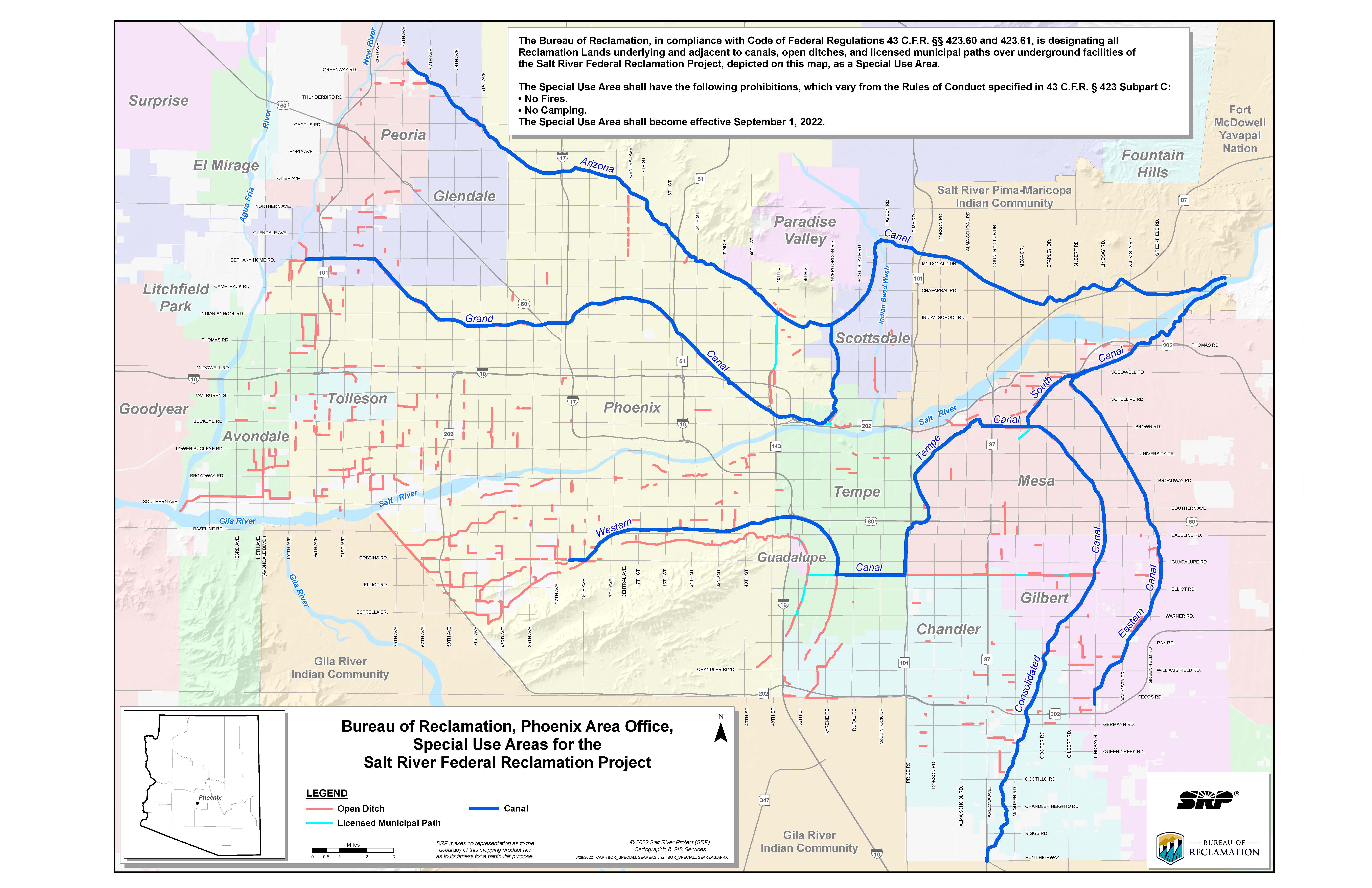

Share:
eBike Shops in Iowa (2026): 54 Verified Stores
Qiolor Tiger JR Review 2026: The $899 Tiger, 500 W